1
Cleppa Park, Newport
Looking along Cleppa Park across the A48 from Pencarn Way
Image: © Jaggery
Taken: 9 Sep 2009
0.04 miles
2
Hexagon House, Cleppa Park, Newport
Formerly occupied by HSBC, this single storey building of steel frame construction was available for purchase in August 2010 at £2.3 million, or to rent at £12 per square foot. The building has 25,736 square feet of space.
Image: © Jaggery
Taken: 25 Sep 2010
0.05 miles
3
A48 traffic lights at the Pencarn Way junction, Newport
Near Cleppa Park. The lorry is turning left into Pencarn Way.
Image: © Jaggery
Taken: 21 Jul 2016
0.05 miles
4
Three-lane carriageway, A48 near Cleppa Park, Newport
On the approach to traffic light http://www.geograph.org.uk/photo/5046279 controlled crossroads again, get in the right side lane for Cleppa Park, the left side lane for Pencarn Way and either the left or middle lane to stay on the A48 towards Castleton and Cardiff.
Image: © Jaggery
Taken: 21 Jul 2016
0.06 miles
5
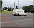
Jangels Transport Services van, Cleppa Park, Newport
On the A48 at the Cleppa Park Industrial Estate junction.
Image: © Jaggery
Taken: 21 Jul 2016
0.06 miles
6
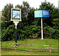
Dragonfly and Holiday Inn Express signs alongside the A48, Newport
Located on the right here. http://www.geograph.org.uk/photo/5103457 http://www.geograph.org.uk/photo/5103425 to a closer view of the Dragonfly sign.
Image: © Jaggery
Taken: 21 Jul 2016
0.07 miles
7
The Dragonfly name sign, Coedkernew
Facing the A48 130 metres north of the Dragonfly pub. http://www.geograph.org.uk/photo/5103532
Image: © Jaggery
Taken: 21 Jul 2016
0.07 miles
8
Lakeside Drive offices, Celtic Springs, Newport
Integra House http://www.geograph.org.uk/photo/5103692 is on the left.
Image: © Jaggery
Taken: 21 Jul 2016
0.07 miles
9
Celtic Springs Business Park name sign, Newport
Viewed across the A48. The north side of a Holiday Inn Express is on the left.
Image: © Jaggery
Taken: 21 Jul 2016
0.07 miles
10
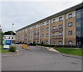
West side of the Holiday Inn Express, Coedkernew, Newport
This is the Lakeside Drive side of the four-storey hotel. The opposite side faces the A48.
Image: © Jaggery
Taken: 21 Jul 2016
0.07 miles


