IMAGES TAKEN NEAR TO
Imperial Park, NEWPORT, NP10 8AS
Introduction
This page details the photographs taken nearby to Imperial Park, NP10 8AS by members of the Geograph project.
The Geograph project started in 2005 with the aim of publishing, organising and preserving representative images for every square kilometre of Great Britain, Ireland and the Isle of Man.

There are currently over 7.5m images from over14,400 individuals and you can help contribute to the project by visiting https://www.geograph.org.uk
Image Map
Images are licensed for reuse under creativecommons.org/licenses/by-sa/2.0
Notes
- Clicking on the map will re-center to the selected point.
- The higher the marker number, the further away the image location is from the centre of the postcode.
Image Listing (34 Images Found)
Images are licensed for reuse under creativecommons.org/licenses/by-sa/2.0
Image
Details
Distance
1

Imperial Park, Newport
Surface Technology Systems
Image: © Kev Griffin
Taken: 16 Nov 2004
0.01 miles
2
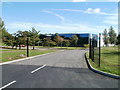
Entrance to STS, Imperial Park, Newport
The entrance from South Lake Drive into the Corporate Headquarters of STS (Surface Technology Systems plc), providers of specialist plasma etch and deposition systems, used in the manufacture of various semiconductor products.
Image: © Jaggery
Taken: 25 Sep 2010
0.03 miles
3
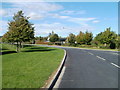
A bend in South Lake Drive, Coedkernew
South Lake Drive heads for Imperial Way. On the right is the turning for STS. http://www.geograph.org.uk/photo/2082050
Image: © Jaggery
Taken: 25 Sep 2010
0.08 miles
4
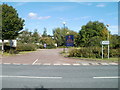
Southern entrance to Imperial Courtyard and University Courtyard, Coedkernew
This entrance is from South Lake Drive.
Image: © Jaggery
Taken: 25 Sep 2010
0.10 miles
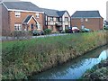
5
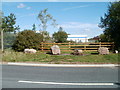
Boulders in front of a wooden fence, South Lake Drive, Coedkernew
As far as I could tell, the row of boulders and fence are guarding an empty field. About 150 metres away, there is similar boulder protection http://www.geograph.org.uk/photo/2081987 on South Lake Drive, in front of metal gates.
Image: © Jaggery
Taken: 25 Sep 2010
0.11 miles
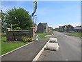
6
The Boulevards
This picture from 2010 shows this location as the entrance to a factory. Image
That has obviously gone and it's now new housing.
Image: © Des Blenkinsopp
Taken: 8 May 2016
0.16 miles
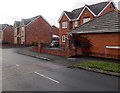
7
Grosmont Way houses, Newport
Detached houses viewed from the corner of Morgraig Avenue.
Image: © Jaggery
Taken: 13 Aug 2018
0.17 miles
8
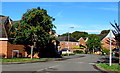
West along Grosmont Way, Newport
The eastern end of Grosmont Way viewed from the roundabout
at the Morgraig Avenue/White Avenue/Grosmont Way crossroads.
Image: © Jaggery
Taken: 13 Aug 2018
0.17 miles
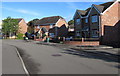
9
Celtic Horizon estate
Celtic Horizon is a recent housing development on the edge of the Wentlooge Level which is criss crossed by reens.
Image: © Robin Drayton
Taken: 3 Dec 2007
0.17 miles
10
Eastern end of Grosmont Way, Newport
Viewed from near the roundabout at the Morgraig Avenue and White Avenue junctions.
Image: © Jaggery
Taken: 21 Dec 2012
0.17 miles