IMAGES TAKEN NEAR TO
Jamaica Circle, NEWPORT, NP10 8AN
Introduction
This page details the photographs taken nearby to Jamaica Circle, NP10 8AN by members of the Geograph project.
The Geograph project started in 2005 with the aim of publishing, organising and preserving representative images for every square kilometre of Great Britain, Ireland and the Isle of Man.

There are currently over 7.5m images from over14,400 individuals and you can help contribute to the project by visiting https://www.geograph.org.uk
Image Map
Images are licensed for reuse under creativecommons.org/licenses/by-sa/2.0
Notes
- Clicking on the map will re-center to the selected point.
- The higher the marker number, the further away the image location is from the centre of the postcode.
Image Listing (367 Images Found)
Images are licensed for reuse under creativecommons.org/licenses/by-sa/2.0
Image
Details
Distance
1
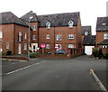
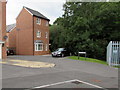
Portobello Court, Duffryn, Newport
Flats viewed across the street named Jamaica Gardens.
Image: © Jaggery
Taken: 10 Aug 2016
0.01 miles
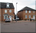
2
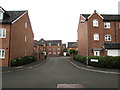
Jamaica Gardens towards Portobello Court, Duffryn, Newport
West along Jamaica Gardens towards Portobello Court. http://www.geograph.org.uk/photo/5068858
Image: © Jaggery
Taken: 10 Aug 2016
0.01 miles
3
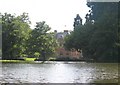
Tredegar House and Lake
Tredegar House, seen from across the lake and surrounded by trees.
Image: © David Roberts
Taken: 15 Jul 2009
0.03 miles
4
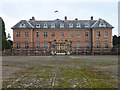
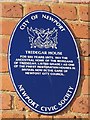
Tredegar House
Tredegar House, one of the best examples of a 17th century Charles II mansion in Britain, is a Grade I listed building. This view across the stable court is towards the original entrance to the house. Around 1850 a new entrance was built on the side of the house and can be seen here http://www.geograph.org.uk/photo/26914 .
Image: © Robin Drayton
Taken: 17 Nov 2007
0.03 miles
5
Jamaica Way, Duffryn, Newport
At the northern edge of 21st century housing on the west side of Duffryn Drive.
Image: © Jaggery
Taken: 10 Aug 2016
0.03 miles
6
Jamaica Grove and Jamaica Gardens, Duffryn, Newport
The Jamaica Grove name sign is on the left side of the lamppost.
The Jamaica Gardens name sign is on the right.
Image: © Jaggery
Taken: 10 Aug 2016
0.04 miles
7
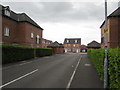
Jamaica Grove towards Jamaica Gardens, Duffryn, Newport
Early 21st century housing viewed from the corner of Duffryn Drive.
Image: © Jaggery
Taken: 10 Aug 2016
0.04 miles
8
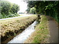
Drainage channel, Duffryn Drive, Newport
A drainage channel on the north side of the road is part of a system supplying the artificial lake in the grounds of Tredegar House. The lake is fed from the Ebbw River. Excess water then flows through a spillway http://www.geograph.org.uk/photo/334718 before leaving the House grounds and flowing towards the camera along this channel. A few metres behind the camera http://www.geograph.org.uk/photo/2449995 the water enters an underground conduit on its way back to the Ebbw.
Image: © Jaggery
Taken: 8 Jun 2011
0.04 miles
10
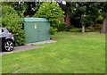
Jamaica Road electricity substation, Duffryn, Newport
The Western Power Distribution electricity substation is located at the northern edge of 21st century housing on the west side of Duffryn Drive. Its identifier is JAMAICA ROAD S/S No. 53-6964.
Image: © Jaggery
Taken: 10 Aug 2016
0.05 miles