IMAGES TAKEN NEAR TO
Telford Close, NEWPORT, NP10 0DL
Introduction
This page details the photographs taken nearby to Telford Close, NP10 0DL by members of the Geograph project.
The Geograph project started in 2005 with the aim of publishing, organising and preserving representative images for every square kilometre of Great Britain, Ireland and the Isle of Man.

There are currently over 7.5m images from over14,400 individuals and you can help contribute to the project by visiting https://www.geograph.org.uk
Image Map
Images are licensed for reuse under creativecommons.org/licenses/by-sa/2.0
Notes
- Clicking on the map will re-center to the selected point.
- The higher the marker number, the further away the image location is from the centre of the postcode.
Image Listing (136 Images Found)
Images are licensed for reuse under creativecommons.org/licenses/by-sa/2.0
Image
Details
Distance
1
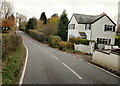
Cefn Cottage, Cwm Lane, Newport
The view southeastwards along Cwm Lane. Cefn Cottage is on the right.
Image: © Jaggery
Taken: 19 Nov 2009
0.05 miles
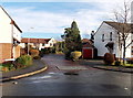
2

Brunel Avenue, Rogerstone
Houses on the south side of Brunel Avenue, close to the junction with Cwm Lane.
Image: © Jaggery
Taken: 19 Nov 2009
0.09 miles
3
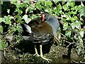
Moorhen beside the canal at Rogerstone
Taking a break from nest building to have a preen.
The Monmouthshire and Brecon Canal near to Fourteen Locks.
Image: © Robin Drayton
Taken: 14 Mar 2022
0.11 miles
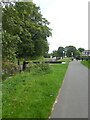
4
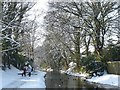
Walkers alongside the canal
This is a stretch of the Crumlin branch of the Monmouthshire and Brecon Canal just to the west of Fourteen Locks http://www.geograph.org.uk/photo/3309334 .
Image: © Robin Drayton
Taken: 24 Jan 2013
0.12 miles
5
![Monmouthshire & Brecon Canal [8]](https://s2.geograph.org.uk/geophotos/01/81/77/1817710_b35b1cd5_120x120.jpg)
Monmouthshire & Brecon Canal [8]
The top lock of Fourteen Locks can be seen in the distance.
Image: © Michael Dibb
Taken: 10 Mar 2010
0.13 miles
6
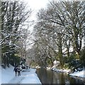
A winter's stroll alongside the canal
This is a stretch of the Crumlin branch of the Monmouthshire and Brecon Canal just to the west of Fourteen Locks http://www.geograph.org.uk/photo/3309334 .
Image: © Robin Drayton
Taken: 24 Jan 2013
0.13 miles
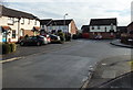
7
Squires Close, Rogerstone, Newport
Viewed from Squires Gate in an area of modern houses on the east side of Ruskin Avenue.
Image: © Jaggery
Taken: 23 Jan 2014
0.13 miles
8
SE edge of Squires Gate, Rogerstone, Newport
Viewed from the corner of Squires Close. http://www.geograph.org.uk/photo/3908856
Squires Gate in an area of modern houses on the east side of Ruskin Avenue.
Image: © Jaggery
Taken: 23 Jan 2014
0.13 miles
9
Lock on Monmouthshire and Brecon Canal near Cefn
Image: © David Smith
Taken: 25 Sep 2021
0.13 miles
10
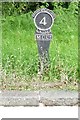
Old milemarker by the Monmouthshire Canal, Crumlin Branch, Lock 21
Milemarker by the Monmouthshire Canal, Crumlin Branch, in parish of Rogerstone (Newport District), at Lock 21 near Fourteen Locks Canal Centre. probably re-sited, see listing.
Inscription reads:-
POTTER STREET LOCK
4
MILES
M.C.C⁰.
Grade II listed by Cadw.
Reference Number: 81341 https://cadwpublic-api.azurewebsites.net/reports/listedbuilding/FullReport?lang=&id=81341
Surveyed
Milestone Society National ID: CRU-04
Image: © Milestone Society
Taken: Unknown
0.13 miles