1
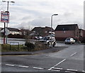
Western end of Squires Gate, Rogerstone, Newport
Viewed across Ruskin Avenue. The street name sign shows Squires Gate leading to Squires Close.
Image: © Jaggery
Taken: 23 Jan 2014
0.05 miles
2
The Olde Oak Inn, Rogerstone, Newport
Pub and restaurant (Squires Bar and The Fourteen Locks Restaurant) in the Mount Pleasant area of Rogerstone, on the corner of Ruskin Avenue and Squires Gate.
Image: © Jaggery
Taken: 23 Jan 2014
0.06 miles
3
Donation bins, Squires Gate, Rogerstone, Newport
Located at the Squires Gate end of The Olde Oak Inn http://www.geograph.org.uk/photo/3908928 car park. The two red bins, a books & music bank and a clothing bank, are for donations to the British Heart Foundation.
Image: © Jaggery
Taken: 23 Jan 2014
0.06 miles
4
Stevenson Close, Rogerstone, Newport
Viewed from the corner of Ruskin Avenue in the Mount Pleasant area of Rogerstone.
Image: © Jaggery
Taken: 23 Jan 2014
0.06 miles
5
Squires Close, Rogerstone, Newport
Viewed from Squires Gate in an area of modern houses on the east side of Ruskin Avenue.
Image: © Jaggery
Taken: 23 Jan 2014
0.06 miles
6
Canal reflections, Rogerstone, Newport
This is a stretch of the Crumlin branch of the Monmouthshire and Brecon Canal to the west of Fourteen Locks https://www.geograph.org.uk/photo/6078609 .
The following shared description is provided by David Dixon.
Image: © Robin Drayton
Taken: 27 Feb 2019
0.07 miles
7
Monmouthshire & Brecon Canal [7]
The canal heads towards the top of Fourteen Locks.
Image: © Michael Dibb
Taken: 10 Mar 2010
0.07 miles
8
Shared-use track by Monmouthshire and Brecon Canal
Image: © David Smith
Taken: 25 Sep 2021
0.07 miles
9
Disused canal ESE of Ruskin Avenue, Rogerstone, Newport
This is the disused Monmouthshire and Brecon canal (Crumlin Arm).
Image: © Jaggery
Taken: 23 Jan 2014
0.07 miles
10
Former canal towpath ESE of Ruskin Avenue, Rogerstone, Newport
The former towpath alongside the disused Monmouthshire and Brecon canal
(Crumlin Arm) is now a footpath and part of National Cycle Network route 47.
Image: © Jaggery
Taken: 23 Jan 2014
0.07 miles


![Monmouthshire & Brecon Canal [7]](https://s0.geograph.org.uk/geophotos/01/81/77/1817708_9b6c2bc9_120x120.jpg)


