IMAGES TAKEN NEAR TO
Grindle Walk, NEWPORT, NP10 0AQ
Introduction
This page details the photographs taken nearby to Grindle Walk, NP10 0AQ by members of the Geograph project.
The Geograph project started in 2005 with the aim of publishing, organising and preserving representative images for every square kilometre of Great Britain, Ireland and the Isle of Man.

There are currently over 7.5m images from over14,400 individuals and you can help contribute to the project by visiting https://www.geograph.org.uk
Image Map
Images are licensed for reuse under creativecommons.org/licenses/by-sa/2.0
Notes
- Clicking on the map will re-center to the selected point.
- The higher the marker number, the further away the image location is from the centre of the postcode.
Image Listing (136 Images Found)
Images are licensed for reuse under creativecommons.org/licenses/by-sa/2.0
Image
Details
Distance
1
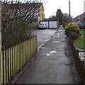
Waterside Walk West, Rogerstone, Newport
Viewed from the corner of Delius Close. The waterside in question is the disused Crumlin Arm of the Monmouthshire & Brecon Canal, behind the houses on the right side of the path.
Image: © Jaggery
Taken: 23 Jan 2014
0.02 miles
2
Delius Close, Rogerstone, Newport
Viewed across Ruskin Avenue looking towards Waterside Walk West.
Image: © Jaggery
Taken: 23 Jan 2014
0.03 miles
3
Gnomes in a canalside garden, Rogerstone
Image: © David Smith
Taken: 25 Sep 2021
0.03 miles
4
Ruskin Avenue passes Delius Close, Rogerstone, Newport
Delius Close http://www.geograph.org.uk/photo/3823899 is on the left. Paxton Walk http://www.geograph.org.uk/photo/3823868 is ahead on the right.
Image: © Jaggery
Taken: 23 Jan 2014
0.03 miles
5
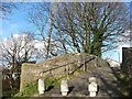
Groes Road canal bridge
Groes Road was closed off in the 1970s when a nearby housing estate was constructed.
Image: © Robin Drayton
Taken: 1 Feb 2008
0.04 miles
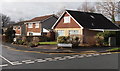
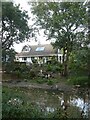
6

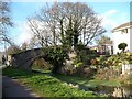
Canal-side houses
These houses have excellent views as well as a lovely water feature at the bottom of their gardens.
Image: © Michael Dibb
Taken: 10 Mar 2010
0.04 miles
7
Canal bridge No. 7
This is the towpath view of Image
Image: © Robin Drayton
Taken: 1 Feb 2008
0.04 miles
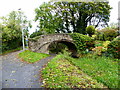
8
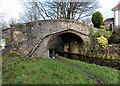
Groes Road canal bridge, Rogerstone, Newport
The bridge carries Groes Road over the disused Monmouthshire and Brecon canal (Crumlin Arm).
Built in the 1790s, the hump-backed bridge was Grade II listed in 2003. Groes Road, formerly a through road for motor vehicles, is now a footpath and cycle route, part of National Cycle Network route 47.
Image: © Jaggery
Taken: 23 Jan 2014
0.04 miles
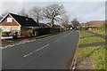
9
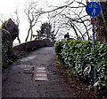
Groes Road approaches a canal bridge, Rogerstone, Newport
Formerly a through road for motor vehicles, Groes Road is now a footpath and cycle route,
part of National Cycle Network route 47. Ahead, it crosses this http://www.geograph.org.uk/photo/3972753 bridge.
Image: © Jaggery
Taken: 23 Jan 2014
0.04 miles
10
Bridge over the Monmouthshire-Brecon Canal, Rogerstone
The bridge links Groes Road with Delius Close. The canal here is only fit for use by wildfowl.
Image: © Ruth Sharville
Taken: 25 Oct 2021
0.04 miles