IMAGES TAKEN NEAR TO
NN9 7LD
Introduction
This page details the photographs taken nearby to NN9 7LD by members of the Geograph project.
The Geograph project started in 2005 with the aim of publishing, organising and preserving representative images for every square kilometre of Great Britain, Ireland and the Isle of Man.

There are currently over 7.5m images from over14,400 individuals and you can help contribute to the project by visiting https://www.geograph.org.uk
Image Map
Images are licensed for reuse under creativecommons.org/licenses/by-sa/2.0
Notes
- Clicking on the map will re-center to the selected point.
- The higher the marker number, the further away the image location is from the centre of the postcode.
Image Listing (9 Images Found)
Images are licensed for reuse under creativecommons.org/licenses/by-sa/2.0
Image
Details
Distance
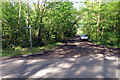
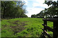
2
Forty Foot Lane
A byway open to all traffic, except from 1st October - 31st March, according to the sign.
Image: © Robin Webster
Taken: 4 Sep 2016
0.12 miles
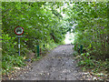
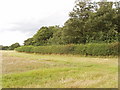
3
Seasonal byway closed by bad weather, near Bozeat
The main byway notice shows it is always closed to motor traffic from 1st October to 31st March. The paer notice below from Bedfordshire County Council says the byway is closed from 21st June 2007, for three months or until the weather improves, to avoid damage to the byway surface. The closed gate is organised so that horses can step over it, and cyclists can lift their bikes over. The byway is part of the Three Shires Way, a 37 mile bridleway.
Image: © David Hawgood
Taken: 13 Aug 2007
0.12 miles
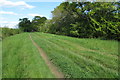
7
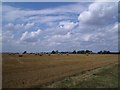
Harvest Gathered in at Dungee Corner
This view of the recently harvested crop looks north-westwards from the Three Shire Bridleway across to Dungee Barn - see SP9259.
Image: © Nigel Stickells
Taken: 16 Aug 2006
0.18 miles
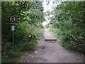
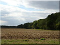
8
Dungee Wood and Three Shires Way, near Bozeat
The footpath runs alongside Dungee Wood to the road at the end of the harvested wheat field.
Image: © David Hawgood
Taken: 13 Aug 2007
0.22 miles
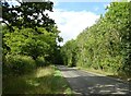
9
Forty Foot Lane byway with Landrover
Image: © Philip Jeffrey
Taken: 12 May 2019
0.25 miles