IMAGES TAKEN NEAR TO
Lamport Crescent, WELLINGBOROUGH, NN9 6UX
Introduction
This page details the photographs taken nearby to Lamport Crescent, NN9 6UX by members of the Geograph project.
The Geograph project started in 2005 with the aim of publishing, organising and preserving representative images for every square kilometre of Great Britain, Ireland and the Isle of Man.

There are currently over 7.5m images from over14,400 individuals and you can help contribute to the project by visiting https://www.geograph.org.uk
Image Map
Images are licensed for reuse under creativecommons.org/licenses/by-sa/2.0
Notes
- Clicking on the map will re-center to the selected point.
- The higher the marker number, the further away the image location is from the centre of the postcode.
Image Listing (7 Images Found)
Images are licensed for reuse under creativecommons.org/licenses/by-sa/2.0
Image
Details
Distance
1
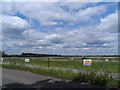
New housing development
The land is being prepared for construction of new houses on the outskirts of town. The white plastic just behind the fence is a newt and reptile barrier-presumably to keep them out so that they don't get killed when the construction starts.
Image: © Bikeboy
Taken: 30 May 2015
0.13 miles
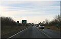
7
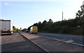
Layby on the A45, Raunds
This was last year https://www.geograph.org.uk/photo/6212937
Image: © David Howard
Taken: 11 Jul 2020
0.24 miles