IMAGES TAKEN NEAR TO
McInnes Way, WELLINGBOROUGH, NN9 6SR
Introduction
This page details the photographs taken nearby to McInnes Way, NN9 6SR by members of the Geograph project.
The Geograph project started in 2005 with the aim of publishing, organising and preserving representative images for every square kilometre of Great Britain, Ireland and the Isle of Man.

There are currently over 7.5m images from over14,400 individuals and you can help contribute to the project by visiting https://www.geograph.org.uk
Image Map
Images are licensed for reuse under creativecommons.org/licenses/by-sa/2.0
Notes
- Clicking on the map will re-center to the selected point.
- The higher the marker number, the further away the image location is from the centre of the postcode.
Image Listing (23 Images Found)
Images are licensed for reuse under creativecommons.org/licenses/by-sa/2.0
Image
Details
Distance
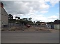
2
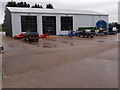
Agricultural suppliers warehouse
Avenue Agricultural, suppliers of earth wearing parts and miscellaneous items for the agricultural and allied trades operate from this site in Raunds.
Image: © Michael Trolove
Taken: 16 Jul 2012
0.13 miles
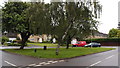
4
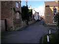
Rotton Row, Raunds
Looking north along the row
Image: © Will Lovell
Taken: 28 Feb 2006
0.20 miles
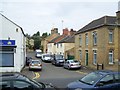

9
North Street at the junction of High Street, Raunds
Image: © David Howard
Taken: 11 Jun 2017
0.22 miles
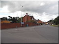
10
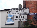
Pre-Worboys signs on the corner of North Street
Northants has done well keeping its pre-Worboys direction signs, there are currently six I know of including these and probably others tucked away.
Image: © David Howard
Taken: 11 Jun 2017
0.22 miles