IMAGES TAKEN NEAR TO
Whitefield Way, WELLINGBOROUGH, NN9 6HF
Introduction
This page details the photographs taken nearby to Whitefield Way, NN9 6HF by members of the Geograph project.
The Geograph project started in 2005 with the aim of publishing, organising and preserving representative images for every square kilometre of Great Britain, Ireland and the Isle of Man.

There are currently over 7.5m images from over14,400 individuals and you can help contribute to the project by visiting https://www.geograph.org.uk
Image Map
Images are licensed for reuse under creativecommons.org/licenses/by-sa/2.0
Notes
- Clicking on the map will re-center to the selected point.
- The higher the marker number, the further away the image location is from the centre of the postcode.
Image Listing (5 Images Found)
Images are licensed for reuse under creativecommons.org/licenses/by-sa/2.0
Image
Details
Distance
1
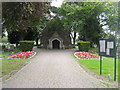
Raunds Cemetery
Raunds Cemetery Chapel
Image: © Shaun Ferguson
Taken: 17 Aug 2009
0.13 miles
2
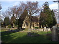
Cemetery, Raunds
The churchyard has long been full and this is the cemetery, to be found in London Road on the edge of town.
Image: © Natasha Ceridwen de Chroustchoff
Taken: 2 Mar 2009
0.13 miles
3

Meadow Lane at the junction of London Road
Image: © David Howard
Taken: 11 Jun 2017
0.20 miles
4

Raunds fire station
Raunds fire station, London Road, Raunds, Northamptonshire
Image: © Kevin Hale
Taken: 5 Dec 2007
0.23 miles
