IMAGES TAKEN NEAR TO
Hargrave, WELLINGBOROUGH, NN9 6BA
Introduction
This page details the photographs taken nearby to NN9 6BA by members of the Geograph project.
The Geograph project started in 2005 with the aim of publishing, organising and preserving representative images for every square kilometre of Great Britain, Ireland and the Isle of Man.

There are currently over 7.5m images from over14,400 individuals and you can help contribute to the project by visiting https://www.geograph.org.uk
Image Map
Images are licensed for reuse under creativecommons.org/licenses/by-sa/2.0
Notes
- Clicking on the map will re-center to the selected point.
- The higher the marker number, the further away the image location is from the centre of the postcode.
Image Listing (6 Images Found)
Images are licensed for reuse under creativecommons.org/licenses/by-sa/2.0
Image
Details
Distance
1
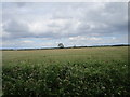
Barley field near New England Farm
Image: © Jonathan Thacker
Taken: 28 Jun 2020
0.15 miles
2
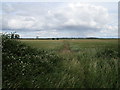
Footpath to Hargrave
Passes through a barley field.
Image: © Jonathan Thacker
Taken: 28 Jun 2020
0.18 miles
3
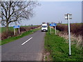
Back road to Raunds
New England Farm to the right
Image: © Les Harvey
Taken: 31 Mar 2007
0.18 miles
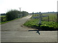
5
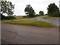
Grass covered road junction near Hargrave
Junction on the Hargrave, Raunds and Newton roads.
Image: © Michael Trolove
Taken: 16 Jul 2012
0.18 miles
6
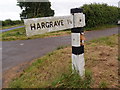
Road sign in poor repair
The sign doesn't look as sprightly as it did in 2007 Image
Image: © Michael Trolove
Taken: 16 Jul 2012
0.18 miles