IMAGES TAKEN NEAR TO
The Glade, WELLINGBOROUGH, NN9 5YW
Introduction
This page details the photographs taken nearby to The Glade, NN9 5YW by members of the Geograph project.
The Geograph project started in 2005 with the aim of publishing, organising and preserving representative images for every square kilometre of Great Britain, Ireland and the Isle of Man.

There are currently over 7.5m images from over14,400 individuals and you can help contribute to the project by visiting https://www.geograph.org.uk
Image Map
Images are licensed for reuse under creativecommons.org/licenses/by-sa/2.0
Notes
- Clicking on the map will re-center to the selected point.
- The higher the marker number, the further away the image location is from the centre of the postcode.
Image Listing (6 Images Found)
Images are licensed for reuse under creativecommons.org/licenses/by-sa/2.0
Image
Details
Distance
1
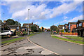
Fallowfield, Redhill Grange
A modern housing estate on the outskirts of Wellingborough.
Image: © David Dixon
Taken: 20 Oct 2021
0.17 miles
2
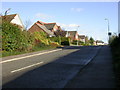
Grange Road
Part of a housing estate off the east side of the old Wellingborough Road which runs parallel to the A509.
Image: © Kokai
Taken: 7 Nov 2005
0.18 miles
3
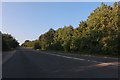
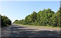
Wellingborough Road
A previous visit https://www.geograph.org.uk/photo/6227031
Image: © David Howard
Taken: 13 Sep 2020
0.21 miles
4
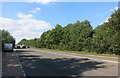
Wellingborough Road heading north
I am consistent. https://www.geograph.org.uk/photo/6203174
Image: © David Howard
Taken: 29 Jul 2019
0.22 miles
5
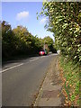
Wellingborough Road heading north
Going towards Kettering
Image: © David Howard
Taken: 29 Jun 2019
0.24 miles
6
The Old Wellingborough Road
The road runs parallel to the A509. View north.
Image: © Kokai
Taken: 7 Nov 2005
0.24 miles