IMAGES TAKEN NEAR TO
Malthouse Close, WELLINGBOROUGH, NN9 5PQ
Introduction
This page details the photographs taken nearby to Malthouse Close, NN9 5PQ by members of the Geograph project.
The Geograph project started in 2005 with the aim of publishing, organising and preserving representative images for every square kilometre of Great Britain, Ireland and the Isle of Man.

There are currently over 7.5m images from over14,400 individuals and you can help contribute to the project by visiting https://www.geograph.org.uk
Image Map
Images are licensed for reuse under creativecommons.org/licenses/by-sa/2.0
Notes
- Clicking on the map will re-center to the selected point.
- The higher the marker number, the further away the image location is from the centre of the postcode.
Image Listing (21 Images Found)
Images are licensed for reuse under creativecommons.org/licenses/by-sa/2.0
Image
Details
Distance
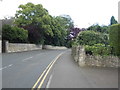
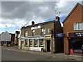
1
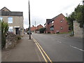
Station Road, Irthlingborough
There are a number of station roads in the area but no stations
Image: © David Howard
Taken: 11 Jun 2017
0.05 miles
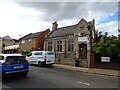
3
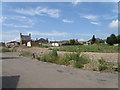
Development land, Irthlingborough
An area of land probably awaiting an uplift in the economic outlook before any redevelopment begins.
Image: © Michael Trolove
Taken: 28 Jun 2009
0.07 miles
5
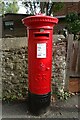
George V postbox on Station Road
Postbox No. NN9 69.
Image: © JThomas
Taken: 23 Sep 2022
0.10 miles
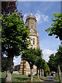
7
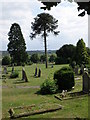
St Peter's Churchyard, Irthlingborough
Not many Monkey Puzzle trees to be seen on the Nene Way
Image: © Michael Trolove
Taken: 28 Jun 2009
0.12 miles