IMAGES TAKEN NEAR TO
Gates Close, WELLINGBOROUGH, NN9 5EF
Introduction
This page details the photographs taken nearby to Gates Close, NN9 5EF by members of the Geograph project.
The Geograph project started in 2005 with the aim of publishing, organising and preserving representative images for every square kilometre of Great Britain, Ireland and the Isle of Man.

There are currently over 7.5m images from over14,400 individuals and you can help contribute to the project by visiting https://www.geograph.org.uk
Image Map
Images are licensed for reuse under creativecommons.org/licenses/by-sa/2.0
Notes
- Clicking on the map will re-center to the selected point.
- The higher the marker number, the further away the image location is from the centre of the postcode.
Image Listing (5 Images Found)
Images are licensed for reuse under creativecommons.org/licenses/by-sa/2.0
Image
Details
Distance
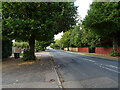
3
Finedon Road Irthlingborough
This is the B5348. It used to be the main A6 London road until it was bypassed in the 1930's, largely to provide unemployment relief.
Image: © Will Lovell
Taken: 20 Jun 2006
0.16 miles
4
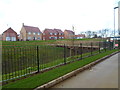
The Lanterns
2010s houses in Irthlingborough.
Image: © Burgess Von Thunen
Taken: 25 Feb 2014
0.18 miles
5
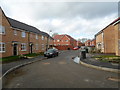
The Lanterns
2010s houses in Irthlingborough.
Image: © Burgess Von Thunen
Taken: 25 Feb 2014
0.18 miles