IMAGES TAKEN NEAR TO
Sywell Road, WELLINGBOROUGH, NN8 6BS
Introduction
This page details the photographs taken nearby to Sywell Road, NN8 6BS by members of the Geograph project.
The Geograph project started in 2005 with the aim of publishing, organising and preserving representative images for every square kilometre of Great Britain, Ireland and the Isle of Man.

There are currently over 7.5m images from over14,400 individuals and you can help contribute to the project by visiting https://www.geograph.org.uk
Image Map
Images are licensed for reuse under creativecommons.org/licenses/by-sa/2.0
Notes
- Clicking on the map will re-center to the selected point.
- The higher the marker number, the further away the image location is from the centre of the postcode.
Image Listing (7 Images Found)
Images are licensed for reuse under creativecommons.org/licenses/by-sa/2.0
Image
Details
Distance
1
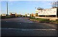
The entrance to Wellingborough Old Grammarians Sports Club
Image: © David Howard
Taken: 30 Oct 2022
0.15 miles
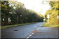
2
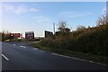
Sywell Road, Wellingborough
At the entrance to Old Grammarians sports ground.
Image: © David Howard
Taken: 30 Oct 2022
0.16 miles
3
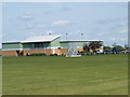
Old Grammarians
Clubhouse with changing rooms etc for the Old Grammarian Rugby Club
From their website "Wellingborough Old Grammarians Rugby Club was originally formed for former pupils of Wellingborough Grammar School to continue playing Rugby Union, after the age of sixteen. The club has now become an "open" club for anyone wishing to play Rugby in the Wellingborough district".
Image: © Dennis simpson
Taken: 10 May 2009
0.16 miles
4
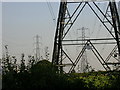
Double Power Line
Taken from Sywell Road looking South.
Image: © Kokai
Taken: 15 Aug 2005
0.20 miles
5
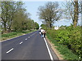
Waendel Walk
Walkers taking part in the 30th Waendel Walk.
Image: © Dennis simpson
Taken: 10 May 2009
0.21 miles
7
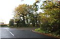
Sywell Road at the junction of Moonshine Gap
Image: © David Howard
Taken: 30 Oct 2022
0.21 miles