IMAGES TAKEN NEAR TO
Barnwell Road, WELLINGBOROUGH, NN8 5LQ
Introduction
This page details the photographs taken nearby to Barnwell Road, NN8 5LQ by members of the Geograph project.
The Geograph project started in 2005 with the aim of publishing, organising and preserving representative images for every square kilometre of Great Britain, Ireland and the Isle of Man.

There are currently over 7.5m images from over14,400 individuals and you can help contribute to the project by visiting https://www.geograph.org.uk
Image Map (Loading...)


Getting Data...Please wait
Leaflet Map data © OpenStreetMap
Images are licensed for reuse under creativecommons.org/licenses/by-sa/2.0
Notes
- Clicking on the map will re-center to the selected point.
- The higher the marker number, the further away the image location is from the centre of the postcode.
Image Listing (5 Images Found)
Images are licensed for reuse under creativecommons.org/licenses/by-sa/2.0
Image
Details
Distance
1
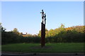
Naked figures entering Wellingborough
There are three more on the other side of the road
Image: © David Howard
Taken: 13 Sep 2020
0.21 miles
2
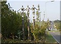
Naked figures entering Wellingborough
There are three more opposite
Image: © David Howard
Taken: 13 Sep 2020
0.21 miles
3
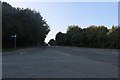
Harrowden Road at the junction of Kilborn Road
Image: © David Howard
Taken: 13 Sep 2020
0.22 miles
4
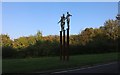
Sculpture on the A5193
One of two identical groups recently erected on either side of Harrowden Road, just south of the A509. Hailed locally as Wellingborough's answer to The Angel of the North. Columns represent Roman history in the district, waving arms refer to the river and the figures themselves represent the town's communities working together.
Image: © Kokai
Taken: 23 Oct 2007
0.22 miles
5
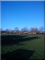
Green space off Kilborn Road
Running along one side of Kilborn Road this green space offers a place for people to play.
Image: © Helen
Taken: 26 Dec 2012
0.23 miles