IMAGES TAKEN NEAR TO
Hatton Street, WELLINGBOROUGH, NN8 5AW
Introduction
This page details the photographs taken nearby to Hatton Street, NN8 5AW by members of the Geograph project.
The Geograph project started in 2005 with the aim of publishing, organising and preserving representative images for every square kilometre of Great Britain, Ireland and the Isle of Man.

There are currently over 7.5m images from over14,400 individuals and you can help contribute to the project by visiting https://www.geograph.org.uk
Image Map (Loading...)


Getting Data...Please wait
Leaflet Map data © OpenStreetMap
Images are licensed for reuse under creativecommons.org/licenses/by-sa/2.0
Notes
- Clicking on the map will re-center to the selected point.
- The higher the marker number, the further away the image location is from the centre of the postcode.
Image Listing (5 Images Found)
Images are licensed for reuse under creativecommons.org/licenses/by-sa/2.0
Image
Details
Distance
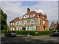
2
Junction of Harrowden Road and Redwell Road
This is Harrowden Road looking south from its junction with Redwell Road.
Image: © Helen
Taken: 26 Dec 2014
0.15 miles
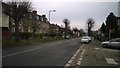
3
Harrowden Road
The A5193 leaving Wellingborough towards the north.
Image: © David Dixon
Taken: 21 Oct 2019
0.21 miles
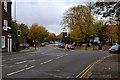
4
Wellingborough: Broad Green
All these ironstone houses and cottages on the east side of Broad Green are Grade II Listed Buildings, and, judging by the steepness of the roof pitches, may originally have been thatched.
Image: © Nigel Cox
Taken: 14 Jun 2019
0.24 miles
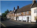
5
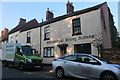
Wellingborough Driving Academy on Broad Green
Image: © David Howard
Taken: 13 Sep 2020
0.24 miles