IMAGES TAKEN NEAR TO
Turner Road, WELLINGBOROUGH, NN8 4UT
Introduction
This page details the photographs taken nearby to Turner Road, NN8 4UT by members of the Geograph project.
The Geograph project started in 2005 with the aim of publishing, organising and preserving representative images for every square kilometre of Great Britain, Ireland and the Isle of Man.

There are currently over 7.5m images from over14,400 individuals and you can help contribute to the project by visiting https://www.geograph.org.uk
Image Map (Loading...)


Getting Data...Please wait
Leaflet Map data © OpenStreetMap
Images are licensed for reuse under creativecommons.org/licenses/by-sa/2.0
Notes
- Clicking on the map will re-center to the selected point.
- The higher the marker number, the further away the image location is from the centre of the postcode.
Image Listing (5 Images Found)
Images are licensed for reuse under creativecommons.org/licenses/by-sa/2.0
Image
Details
Distance
1
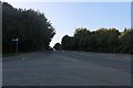
Harrowden Road at the junction of Kilborn Road
Image: © David Howard
Taken: 13 Sep 2020
0.10 miles
2
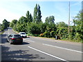
Harrowden Road
Near Kettering Road Bridge.
Image: © Burgess Von Thunen
Taken: 11 Jun 2014
0.10 miles
3
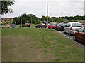
Fairly Major Roundabout
This junction carries Niort Way, Northen Way, Harrowden Road, Kettering Road and the minor Wellingborough Road. The photo was taken from Kettering Road.
Image: © Kokai
Taken: 26 Jul 2005
0.13 miles
4
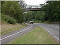
Bridge over Harrowden Road
Near the Redwell Leisure Centre.
Image: © Kokai
Taken: 26 Jul 2005
0.13 miles
5
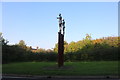
Naked figures entering Wellingborough
There are three more on the other side of the road
Image: © David Howard
Taken: 13 Sep 2020
0.25 miles