IMAGES TAKEN NEAR TO
The Avenue, WELLINGBOROUGH, NN8 4ET
Introduction
This page details the photographs taken nearby to The Avenue, NN8 4ET by members of the Geograph project.
The Geograph project started in 2005 with the aim of publishing, organising and preserving representative images for every square kilometre of Great Britain, Ireland and the Isle of Man.

There are currently over 7.5m images from over14,400 individuals and you can help contribute to the project by visiting https://www.geograph.org.uk
Image Map
Images are licensed for reuse under creativecommons.org/licenses/by-sa/2.0
Notes
- Clicking on the map will re-center to the selected point.
- The higher the marker number, the further away the image location is from the centre of the postcode.
Image Listing (7 Images Found)
Images are licensed for reuse under creativecommons.org/licenses/by-sa/2.0
Image
Details
Distance
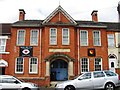
2
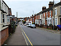
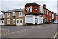
Wellingborough, Havelock Street
Victorian terraced houses near the town centre.
Image: © David Dixon
Taken: 21 Oct 2019
0.16 miles
3
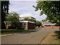
Sir Christopher Hatton School
A large co-educational comprehensive school.
Image: © Kokai
Taken: 18 Jul 2005
0.18 miles
4
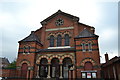
Great Park Street Methodist Church, Wellingborough
This is the largest Methodist Church building in Wellingborough, built in 1872. The building was extended to the rear to provide school rooms and to the right to create a hall in 1914.
Image: © Helen
Taken: 21 Jul 2014
0.18 miles
5
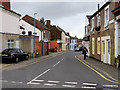
Corner Shop
Former shop at the corner of Havelock Street and Herriotts lane. The datestone indicates that these buildings were built in 1890.
Image: © David Dixon
Taken: 21 Oct 2019
0.18 miles
7
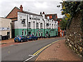
The Gloucester
Town centre pub on Church Street.
Image: © David Dixon
Taken: 21 Oct 2019
0.25 miles