IMAGES TAKEN NEAR TO
Covington Grove, WELLINGBOROUGH, NN8 4ED
Introduction
This page details the photographs taken nearby to Covington Grove, NN8 4ED by members of the Geograph project.
The Geograph project started in 2005 with the aim of publishing, organising and preserving representative images for every square kilometre of Great Britain, Ireland and the Isle of Man.

There are currently over 7.5m images from over14,400 individuals and you can help contribute to the project by visiting https://www.geograph.org.uk
Image Map
Images are licensed for reuse under creativecommons.org/licenses/by-sa/2.0
Notes
- Clicking on the map will re-center to the selected point.
- The higher the marker number, the further away the image location is from the centre of the postcode.
Image Listing (3 Images Found)
Images are licensed for reuse under creativecommons.org/licenses/by-sa/2.0
Image
Details
Distance
1
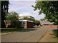
Sir Christopher Hatton School
A large co-educational comprehensive school.
Image: © Kokai
Taken: 18 Jul 2005
0.07 miles
2
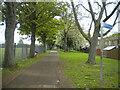
Footpath off Gold Street, Wellingborough
Between school playing fields (left) and house backs. The sign points to Hemmingwell, but apparently refers to another path heading away out of frame.
Image: © Richard Vince
Taken: 7 May 2022
0.13 miles
3
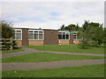
Oakway Infants School
On the Hemingwell Estate
Image: © Kokai
Taken: 14 Sep 2005
0.17 miles