IMAGES TAKEN NEAR TO
Alma Street, WELLINGBOROUGH, NN8 4DH
Introduction
This page details the photographs taken nearby to Alma Street, NN8 4DH by members of the Geograph project.
The Geograph project started in 2005 with the aim of publishing, organising and preserving representative images for every square kilometre of Great Britain, Ireland and the Isle of Man.

There are currently over 7.5m images from over14,400 individuals and you can help contribute to the project by visiting https://www.geograph.org.uk
Image Map
Images are licensed for reuse under creativecommons.org/licenses/by-sa/2.0
Notes
- Clicking on the map will re-center to the selected point.
- The higher the marker number, the further away the image location is from the centre of the postcode.
Image Listing (61 Images Found)
Images are licensed for reuse under creativecommons.org/licenses/by-sa/2.0
Image
Details
Distance
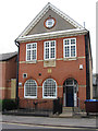
1
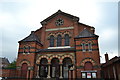
Great Park Street Methodist Church, Wellingborough
This is the largest Methodist Church building in Wellingborough, built in 1872. The building was extended to the rear to provide school rooms and to the right to create a hall in 1914.
Image: © Helen
Taken: 21 Jul 2014
0.06 miles
2
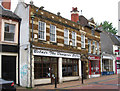
Wellingborough - building dated 1907 on Cambridge Street
Image: © Dave Bevis
Taken: 9 Jun 2012
0.07 miles
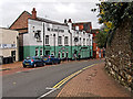
3
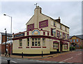
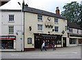
Wellingborough - The Rising Sun
On Mill Road.
Image: © Dave Bevis
Taken: 9 Jun 2012
0.07 miles
4
Wellingborough: The Rising Sun
The Rising Sun is on Mill Road at its junction with Victoria Road. It is shown on the large scale Ordnance Survey map of 1886, opposite the former Victoria Theatre.
The road configuration here at that time was markedly different from today's layout. Victoria Road stopped at a T-junction with Mill Road and Cambridge Street, which themselves formed a continuous thoroughfare, while Cannon Street took off from Cambridge Street along what is now the side access to the west of the traffic island with the trees. There were then buildings adjoining The Rising Sun on this side of it.
Image: © Nigel Cox
Taken: 14 Jun 2019
0.08 miles
6
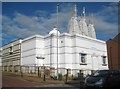
Wellingborough: BAPS Shri Swaminarayan Mandir
A Mandir is a sacred Hindu place of worship, representing the earthly home of Bhagwan. This Bochasanwasi Akshar Purushottam Sanstha (BAPS) mandir is on Mill Road with the main entrance on Victoria Road. Its website is here https://www.baps.org/Global-Network/UK-and-Europe/Wellingborough.aspx
Old Streetview images show the mandir under construction in December 2010, but open in August 2014.
Old large scale Ordnance Survey maps show that it occupies the site of the former Victoria Theatre, and latterly a timber yard.
Image: © Nigel Cox
Taken: 14 Jun 2019
0.09 miles
7
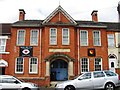
Wellingborough - Masonic Hall
On Mill Road.
Image: © Dave Bevis
Taken: 9 Jun 2012
0.10 miles
8
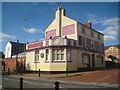
The Gloucester
Town centre pub on Church Street.
Image: © David Dixon
Taken: 21 Oct 2019
0.11 miles
10
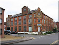
Wellingborough - Gilmour & Vale engineering works
On Mill Road.
Image: © Dave Bevis
Taken: 9 Jun 2012
0.14 miles