IMAGES TAKEN NEAR TO
Shelley Road, WELLINGBOROUGH, NN8 3EW
Introduction
This page details the photographs taken nearby to Shelley Road, NN8 3EW by members of the Geograph project.
The Geograph project started in 2005 with the aim of publishing, organising and preserving representative images for every square kilometre of Great Britain, Ireland and the Isle of Man.

There are currently over 7.5m images from over14,400 individuals and you can help contribute to the project by visiting https://www.geograph.org.uk
Image Map (Loading...)


Getting Data...Please wait
Leaflet Map data © OpenStreetMap
Images are licensed for reuse under creativecommons.org/licenses/by-sa/2.0
Notes
- Clicking on the map will re-center to the selected point.
- The higher the marker number, the further away the image location is from the centre of the postcode.
Image Listing (2 Images Found)
Images are licensed for reuse under creativecommons.org/licenses/by-sa/2.0
Image
Details
Distance
1
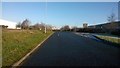
Booth Drive, Park Farm South Industrial Estate
A view of Booth Drive looking North. The large building on the right is currently owned by the Musgrave Group and is a regional distribution centre for chains including Budgens and Londis.
Image: © Helen
Taken: 29 Dec 2014
0.20 miles
2
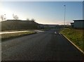
Booth Drive, Park Farm South
This is one of the roads on the Park Farm South Industrial Estate.
Image: © Helen
Taken: 29 Dec 2014
0.22 miles