IMAGES TAKEN NEAR TO
Wilby Park, WELLINGBOROUGH, NN8 2UL
Introduction
This page details the photographs taken nearby to Wilby Park, NN8 2UL by members of the Geograph project.
The Geograph project started in 2005 with the aim of publishing, organising and preserving representative images for every square kilometre of Great Britain, Ireland and the Isle of Man.

There are currently over 7.5m images from over14,400 individuals and you can help contribute to the project by visiting https://www.geograph.org.uk
Image Map
Images are licensed for reuse under creativecommons.org/licenses/by-sa/2.0
Notes
- Clicking on the map will re-center to the selected point.
- The higher the marker number, the further away the image location is from the centre of the postcode.
Image Listing (5 Images Found)
Images are licensed for reuse under creativecommons.org/licenses/by-sa/2.0
Image
Details
Distance
1
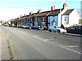
Houses along Main Road
An assortment of detached, semi-detached and terraced housing.
Image: © John Baker
Taken: 15 Feb 2019
0.13 miles
3
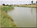
Fishing Lake
No membership required for fishing rights. Council-owned.
Image: © Kokai
Taken: 13 Jul 2005
0.24 miles
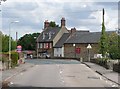
4
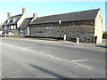
George Inn, Main Road
It is a grade II listed building, which dates from the early 18th century. It has a brick extension, which is attached to an 18th century barn with a 19th century roof
https://britishlistedbuildings.co.uk/101192028-the-george-inn-public-house-and-barn-attached-to-west-wilby#.XIFrsP43bcc
Image: © John Baker
Taken: 15 Feb 2019
0.24 miles
5
The George Inn, Wilby
The zoom lens makes me lazy!
Image: © Humphrey Bolton
Taken: 25 Aug 2011
0.25 miles