IMAGES TAKEN NEAR TO
Church Lane, WELLINGBOROUGH, NN8 2UG
Introduction
This page details the photographs taken nearby to Church Lane, NN8 2UG by members of the Geograph project.
The Geograph project started in 2005 with the aim of publishing, organising and preserving representative images for every square kilometre of Great Britain, Ireland and the Isle of Man.

There are currently over 7.5m images from over14,400 individuals and you can help contribute to the project by visiting https://www.geograph.org.uk
Image Map
Images are licensed for reuse under creativecommons.org/licenses/by-sa/2.0
Notes
- Clicking on the map will re-center to the selected point.
- The higher the marker number, the further away the image location is from the centre of the postcode.
Image Listing (13 Images Found)
Images are licensed for reuse under creativecommons.org/licenses/by-sa/2.0
Image
Details
Distance
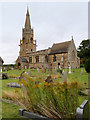
1
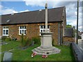
The war memorial, Wilby
In a corner of the churchyard, next to the road and school.
Image: © Humphrey Bolton
Taken: 25 Aug 2011
0.01 miles
2
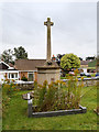
Wilby War Memorial
The war memorial stands at the corner of St Mary's churchyard, next to the school and the road. The inscriptions are faded and difficult to read but a list of names can be found at https://wilbynorthants.files.wordpress.com/2014/07/war-memorial-names1.pdf and https://wilbynorthants.files.wordpress.com/2014/07/war-memorial-names21.pdf
Image: © David Dixon
Taken: 7 Sep 2016
0.02 miles
3
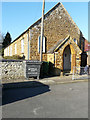
Wilby Church of England Primary School
It is located in Church Lane.
Image: © John Baker
Taken: 15 Feb 2019
0.03 miles
4
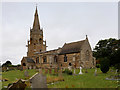
Wilby, St Mary's Church
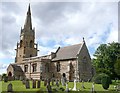
St Mary’s Church dates from the 13th century when the previous Norman church was rebuilt. It is constructed with local pale banded limestone and deep brown ironstone, and stands within raised churchyard.
Parts of the church, particularly the Chancel, were rebuilt/restored during Victorian times when the vestry and organ chamber were added and the stained glass windows inserted. The south aisle remains unchanged with traces of medieval glass to be found. The tower and spire, in the Decorated Style is considered to be one of the most attractive in Northamptonshire (https://www.achurchnearyou.com/wilby/ A Church Near You). The tower is square at the base, then octagonal with a spire and a parapet of quatrefoils with corner pinnacles and miniature flying buttresses. The tower contains a peal of six bells and has an excellent and enthusiastic team of bell ringers.
The church is a Grade II* listed building (List entry Number: 1040680 https://historicengland.org.uk/listing/the-list/list-entry/1040680 Historic England).
Image: © David Dixon
Taken: 7 Sep 2016
0.03 miles
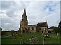
5
St Mary's Church, Wilby
A big church for a little village, and with a remarkable tower and spire with flying buttresses and a parapet like a crown.
Image: © Humphrey Bolton
Taken: 25 Aug 2011
0.04 miles
6
The Church of St Mary the Virgin, Wilby
St Mary’s Church dates from the 13th century when the previous Norman church was rebuilt. It is constructed with local pale banded limestone and deep brown ironstone, and stands within raised churchyard.
Parts of the church, particularly the Chancel, were rebuilt/restored during Victorian times when the vestry and organ chamber were added and the stained glass windows inserted. The south aisle remains unchanged with traces of medieval glass to be found. The tower and spire, in the Decorated Style is considered to be one of the most attractive in Northamptonshire (https://www.achurchnearyou.com/wilby/ A Church Near You). The tower is square at the base, then octagonal with a spire and a parapet of quatrefoils with corner pinnacles and miniature flying buttresses. The tower contains a peal of six bells and has an excellent and enthusiastic team of bell ringers.
The church is a Grade II* listed building (List entry Number: 1040680 https://historicengland.org.uk/listing/the-list/list-entry/1040680 Historic England).
Image: © David Dixon
Taken: 7 Sep 2016
0.04 miles
7
St Mary's Church
https://www.geograph.org.uk/photo/5114893
Image: © JThomas
Taken: 21 Sep 2022
0.04 miles
9
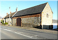
Manor House, Main Road
It is a grade II listed manor house, which dates from the mid 18th century
https://britishlistedbuildings.co.uk/101040684-manor-house-wilby#.XIAWlf43bcc
The adjoining barn is also grade II listed. It dates from the mid 18th century but was altered in the 19th century https://historicengland.org.uk/listing/the-list/list-entry/1286795
This picture of Image shows the house, when its exterior walls were rendered and painted.
Image: © John Baker
Taken: 15 Feb 2019
0.06 miles
10
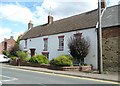
The Manor House, Wilby
The building on the right looks like a long barn; it has a central broad arched doorway.
Image: © Humphrey Bolton
Taken: 25 Aug 2011
0.08 miles