IMAGES TAKEN NEAR TO
Doddington Road, WELLINGBOROUGH, NN8 2JJ
Introduction
This page details the photographs taken nearby to Doddington Road, NN8 2JJ by members of the Geograph project.
The Geograph project started in 2005 with the aim of publishing, organising and preserving representative images for every square kilometre of Great Britain, Ireland and the Isle of Man.

There are currently over 7.5m images from over14,400 individuals and you can help contribute to the project by visiting https://www.geograph.org.uk
Image Map
Images are licensed for reuse under creativecommons.org/licenses/by-sa/2.0
Notes
- Clicking on the map will re-center to the selected point.
- The higher the marker number, the further away the image location is from the centre of the postcode.
Image Listing (5 Images Found)
Images are licensed for reuse under creativecommons.org/licenses/by-sa/2.0
Image
Details
Distance
1
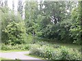
Pocket Park
The bridge on the image is one of two entrances to the area across Swanspool Brook.
Image: © Kokai
Taken: 6 Jun 2006
0.16 miles
2
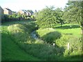
Wellingborough: Swanspool Brook
Swanspool Brook is a tributary of the River Ise, and flows through the centre of Wellingborough. This is the view looking downstream from the downstream end of the culvert under Croyland Road.
Image: © Nigel Cox
Taken: 14 Jun 2019
0.18 miles
3
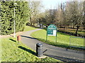
Croyland Gardens
From Monks Way. A path, which can be used by cyclists as well as pedestrians, was constructed to follow the Swanspool Brook.
Image: © John Baker
Taken: 15 Feb 2019
0.18 miles
4
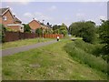
Section of Croyland Cycleway
The cycleway runs from near Wilby to Wellingborough town centre.
Image: © Kokai
Taken: 6 Jun 2006
0.19 miles
5
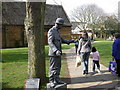
Living Statue in front of Tithe Barn, Wellingborough
The town was enjoying an Arts Festival.
Image: © Kokai
Taken: 26 Mar 2005
0.24 miles