IMAGES TAKEN NEAR TO
Princess Way, WELLINGBOROUGH, NN8 2EZ
Introduction
This page details the photographs taken nearby to Princess Way, NN8 2EZ by members of the Geograph project.
The Geograph project started in 2005 with the aim of publishing, organising and preserving representative images for every square kilometre of Great Britain, Ireland and the Isle of Man.

There are currently over 7.5m images from over14,400 individuals and you can help contribute to the project by visiting https://www.geograph.org.uk
Image Map
Images are licensed for reuse under creativecommons.org/licenses/by-sa/2.0
Notes
- Clicking on the map will re-center to the selected point.
- The higher the marker number, the further away the image location is from the centre of the postcode.
Image Listing (9 Images Found)
Images are licensed for reuse under creativecommons.org/licenses/by-sa/2.0
Image
Details
Distance
1
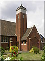
St. Andrews Church
The Church Hall is to the right.
Image: © Kokai
Taken: 13 Jul 2005
0.18 miles
2
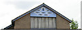
Decoration on St Andrews Church Hall
The hall is extensively used for various children's play groups and activities for the elderly.
Image: © Kokai
Taken: 13 Jul 2005
0.18 miles
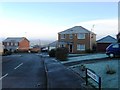
3
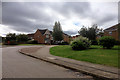
Bourton Way
Housing estate on the southern outskirts of Wellingborough.
Image: © David Dixon
Taken: 6 Sep 2016
0.22 miles
4
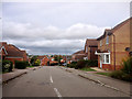
Cotswold Drive, Wellingborough
Part of a modern housing estate on the southern outskirts of Wellingborough.
Image: © David Dixon
Taken: 6 Sep 2016
0.22 miles
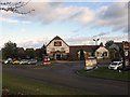
6
The Priory, Wellingborough
Pub/restaurant on Bourton Way, on the southern outskirts of Wellingborough.
Image: © David Dixon
Taken: 6 Sep 2016
0.23 miles
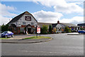
8
The Priory
A pub on the edge of Wellingborough.
Image: © Burgess Von Thunen
Taken: 4 May 2010
0.24 miles
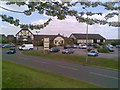
9
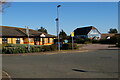
Busy Bees Nursery and The Priory pub, Wellingborough
Part of an area of new estates and services on the edge of town.
Image: © Christopher Hilton
Taken: 27 Feb 2022
0.25 miles