IMAGES TAKEN NEAR TO
Claudius Way, WELLINGBOROUGH, NN8 2DH
Introduction
This page details the photographs taken nearby to Claudius Way, NN8 2DH by members of the Geograph project.
The Geograph project started in 2005 with the aim of publishing, organising and preserving representative images for every square kilometre of Great Britain, Ireland and the Isle of Man.

There are currently over 7.5m images from over14,400 individuals and you can help contribute to the project by visiting https://www.geograph.org.uk
Image Map (Loading...)


Getting Data...Please wait
Leaflet Map data © OpenStreetMap
Images are licensed for reuse under creativecommons.org/licenses/by-sa/2.0
Notes
- Clicking on the map will re-center to the selected point.
- The higher the marker number, the further away the image location is from the centre of the postcode.
Image Listing (3 Images Found)
Images are licensed for reuse under creativecommons.org/licenses/by-sa/2.0
Image
Details
Distance
2
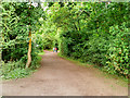
Path in Irchester Country Park
Irchester Country Park which was created from opencast ironstone quarries which were allowed to revert to a wilder landscape after they were worked out some decades after the war. It is managed by Northamptonshire County Council.
Image: © David Dixon
Taken: 6 Sep 2016
0.23 miles