IMAGES TAKEN NEAR TO
The Drive, WELLINGBOROUGH, NN8 2DE
Introduction
This page details the photographs taken nearby to The Drive, NN8 2DE by members of the Geograph project.
The Geograph project started in 2005 with the aim of publishing, organising and preserving representative images for every square kilometre of Great Britain, Ireland and the Isle of Man.

There are currently over 7.5m images from over14,400 individuals and you can help contribute to the project by visiting https://www.geograph.org.uk
Image Map
Images are licensed for reuse under creativecommons.org/licenses/by-sa/2.0
Notes
- Clicking on the map will re-center to the selected point.
- The higher the marker number, the further away the image location is from the centre of the postcode.
Image Listing (6 Images Found)
Images are licensed for reuse under creativecommons.org/licenses/by-sa/2.0
Image
Details
Distance
1
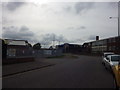
Dennington Road, Wellingborough
Gateway to a significant number of light-industrial units and where the urban fringe begins.
Image: © Stuart Shepherd
Taken: 10 Oct 2015
0.12 miles
2
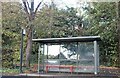
Bus shelter on London Road, Wellingborough
Image: © David Howard
Taken: 30 Oct 2022
0.14 miles
4
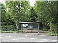
Bus shelter on London Road, Wellingborough
Image: © David Howard
Taken: 11 Jun 2017
0.15 miles
5
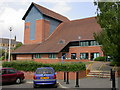
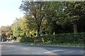
The Castle
Built in the 1990's. Entertaintments include plays, comedy evenings, films, music, dance, pantomime, art exhibitions. Used as the starting and finishing point for the annual International Waendel Walks Weekend.
Image: © Kokai
Taken: 14 Jul 2005
0.20 miles
6
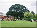
Sports Day at Wellingborough School
The playing fields roll down to the river and a large leafy tree spreads across this view
Image: © Ruth Thomas
Taken: 8 Jul 2006
0.20 miles