IMAGES TAKEN NEAR TO
Bridge Street, NORTHAMPTON, NN7 4PW
Introduction
This page details the photographs taken nearby to Bridge Street, NN7 4PW by members of the Geograph project.
The Geograph project started in 2005 with the aim of publishing, organising and preserving representative images for every square kilometre of Great Britain, Ireland and the Isle of Man.

There are currently over 7.5m images from over14,400 individuals and you can help contribute to the project by visiting https://www.geograph.org.uk
Image Map
Images are licensed for reuse under creativecommons.org/licenses/by-sa/2.0
Notes
- Clicking on the map will re-center to the selected point.
- The higher the marker number, the further away the image location is from the centre of the postcode.
Image Listing (138 Images Found)
Images are licensed for reuse under creativecommons.org/licenses/by-sa/2.0
Image
Details
Distance
2

Houses with verandah - Weedon Bec
These fine houses are opposite the former ordnance depot and royal bolt-hole of Weedon Bec and are probably in some way related.
Image: © Chris Allen
Taken: 14 Oct 2012
0.02 miles
3

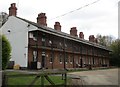
Weedon Bec: Former Ordnance Depot Fireman's Quarters
This structure was originally built in the mid to late 19th century as quarters for firemen at the very nearby ordnance depot. The building is unusual in having the roof of this, the front elevation, extending over an iron-framed balcony and verandah in front of both the ground and first floors. Originally there were 6 flats to each floor, but the building has since been taken over as council flats and there are now only 3 flats to each floor. It is Grade II Listed.
Image: © Nigel Cox
Taken: 3 May 2015
0.02 miles
4
Former firemens' lodgings
Attached to the former Royal Ordnance Depot.
Image: © Jonathan Thacker
Taken: 28 Apr 2017
0.02 miles
5

Old Boundary Marker
War Department Boundary Marker on the southeast side of Bridge Street, against the hedge surrounding The Flats, the former firemen's quarters of the now disused Central Ordnance Depot. Weedon Bec parish. Inscribed W ↑ D / No 6 (only the 6 is clear).
Milestone Society National ID: NR_WDWEED06em
Image: © M Bardell
Taken: 14 Aug 2020
0.04 miles
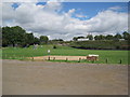
6
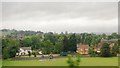
Weedon Jubilee Fields
Large recreation ground off Bridge Street.
Image: © Ian Rob
Taken: 2 Jul 2010
0.04 miles

9
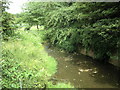
Weedon-River Nene
Flowing under bridge Street into Jubilee Field.
Image: © Ian Rob
Taken: 2 Jul 2010
0.05 miles
10
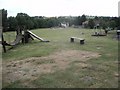
Weedon Bec Jubilee Playing Field
Railway embankment at the bottom of the field
Image: © Les Hull
Taken: 11 Aug 2013
0.05 miles