
IMAGES TAKEN NEAR TO
Brockhall Road, NORTHAMPTON, NN7 4NG
Introduction
This page details the photographs taken nearby to Brockhall Road, NN7 4NG by members of the Geograph project.
The Geograph project started in 2005 with the aim of publishing, organising and preserving representative images for every square kilometre of Great Britain, Ireland and the Isle of Man.

There are currently over 7.5m images from over14,400 individuals and you can help contribute to the project by visiting https://www.geograph.org.uk
Image Map
Images are licensed for reuse under creativecommons.org/licenses/by-sa/2.0
Notes
- Clicking on the map will re-center to the selected point.
- The higher the marker number, the further away the image location is from the centre of the postcode.
Image Listing (21 Images Found)
Images are licensed for reuse under creativecommons.org/licenses/by-sa/2.0
Image
Details
Distance
2
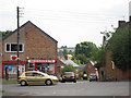
High Street / Brockhall Road junction
Image: © Oast House Archive
Taken: 1 Jul 2011
0.13 miles
3
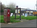
Flore: postbox № NN7 329
An Elizabeth II-reign postbox set into a brick pillar outside Flore Post Office. It has recently received a lick of paint judging by the word WET chalked onto the top of the pillar.
Image: © Chris Downer
Taken: 17 Apr 2009
0.13 miles
5
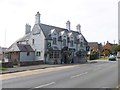
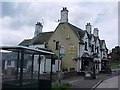
Flore, White Hart
Pub on High Street (A45).
Image: © Mike Faherty
Taken: 17 Sep 2014
0.13 miles

7
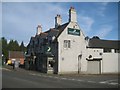
Flore: White Hart
This public house is on the A45 High Street.
Image: © Nigel Cox
Taken: 4 Jul 2015
0.13 miles
8
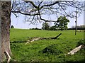
Footpath from Flore
North of the A45 in Flore, a footpath heads across this pasture towards the M1.
Image: © Graham Horn
Taken: 26 Apr 2007
0.14 miles
9
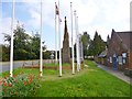
Flore, war memorial
On High Street, in front of the village hall (to the right); recording the deaths of 26 fallen in WWI and 9 in WWII.
Image: © Mike Faherty
Taken: 17 Sep 2014
0.14 miles
10
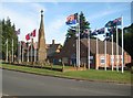
Flore: The War Memorial and Millennium Hall
The War Memorial is a prominent feature on the A45 High Street in Flore. It is a Grade II Listed Structure and the English Heritage website describes it thus:-
"1923. Duston stone. Triangular with chamfered corners giving way to hexagonal pinnacle bearing the Military Cross in white marble. At the foor [sic] of south side a red granite plaque inscribed with names of those commemorated. At the head of same side a sundial with rising sun above and inscription below: Post Tenebris. Other two sides have crest of the Royal Artillery and arms of the Northamptonshire Regiment. Commemorates those connected with parish who died in World War I. Stepped plinth. Unveiling ceremony performed by Earl Spencer on September 30th 1923. An unusual design inspired by the Eleanor Cross at Geddington." This comment appears in itself to have been taken directly from Kelly's Directory of Northamptonshire 1924. In fact a second plaque is now present below the first commemorating Flore's casualties during the Second World War.
The Millennium Hall beyond does not look as if it was constructed in 2000 and is probably the village hall renamed.
Image: © Nigel Cox
Taken: 4 Jul 2015
0.15 miles