IMAGES TAKEN NEAR TO
Bricketts Lane, NORTHAMPTON, NN7 4LU
Introduction
This page details the photographs taken nearby to Bricketts Lane, NN7 4LU by members of the Geograph project.
The Geograph project started in 2005 with the aim of publishing, organising and preserving representative images for every square kilometre of Great Britain, Ireland and the Isle of Man.

There are currently over 7.5m images from over14,400 individuals and you can help contribute to the project by visiting https://www.geograph.org.uk
Image Map
Images are licensed for reuse under creativecommons.org/licenses/by-sa/2.0
Notes
- Clicking on the map will re-center to the selected point.
- The higher the marker number, the further away the image location is from the centre of the postcode.
Image Listing (34 Images Found)
Images are licensed for reuse under creativecommons.org/licenses/by-sa/2.0
Image
Details
Distance
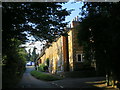
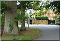
4
The Avenue
Looking down the Avenue from the A45.
Image: © Richard Smith
Taken: 21 Mar 2009
0.06 miles
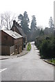
5
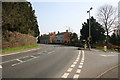
Flore Bends
There are two big bends on the A45 in Flore, this is the one closest to the village with the Avenue going off to the right.
Image: © Richard Smith
Taken: 21 Mar 2009
0.06 miles
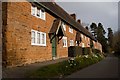
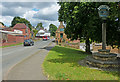
6
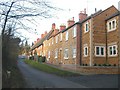
Flore
Row of Cottages Old and New near junction with A45
Image: © Ian Rob
Taken: 16 Dec 2005
0.09 miles
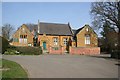
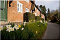
10
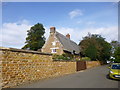
Flore, Rock Springs
C17 thatched stone cottage on Sutton Street, listed by English Heritage: http://www.imagesofengland.org.uk/Details/Default.aspx?id=360770&mode=adv
Image: © Mike Faherty
Taken: 17 Sep 2014
0.13 miles