IMAGES TAKEN NEAR TO
Rugby Road, NORTHAMPTON, NN7 4ER
Introduction
This page details the photographs taken nearby to Rugby Road, NN7 4ER by members of the Geograph project.
The Geograph project started in 2005 with the aim of publishing, organising and preserving representative images for every square kilometre of Great Britain, Ireland and the Isle of Man.

There are currently over 7.5m images from over14,400 individuals and you can help contribute to the project by visiting https://www.geograph.org.uk
Image Map
Images are licensed for reuse under creativecommons.org/licenses/by-sa/2.0
Notes
- Clicking on the map will re-center to the selected point.
- The higher the marker number, the further away the image location is from the centre of the postcode.
Image Listing (7 Images Found)
Images are licensed for reuse under creativecommons.org/licenses/by-sa/2.0
Image
Details
Distance
1
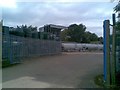
Watson Petroleum
Fuel Depot off the A428.
Image: © Burgess Von Thunen
Taken: 20 Jul 2010
0.01 miles
2
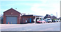
Service station on the A428
Between Harlestone and Althorp.
Image: © Jonathan Billinger
Taken: 5 Apr 2007
0.02 miles
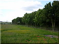
3
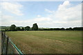
Paddocks near Lower Harlestone
A group of properties on this part of the A428 have paddocks sloping down towards Brampton Brook.
Image: © Burgess Von Thunen
Taken: 30 Jun 2010
0.06 miles
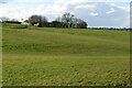
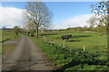
5
Harlestone Farmland
Farmland to the north of the junction of Glebe Lane and the A428.
Image: © Ian Rob
Taken: 13 Jun 2009
0.21 miles
7
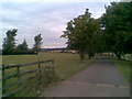
Glebe Farm
The entrance to Glebe Farm is also a bridleway leading to Holdenby.
Image: © Burgess Von Thunen
Taken: 20 Jul 2010
0.23 miles