IMAGES TAKEN NEAR TO
West End, NORTHAMPTON, NN7 3PF
Introduction
This page details the photographs taken nearby to West End, NN7 3PF by members of the Geograph project.
The Geograph project started in 2005 with the aim of publishing, organising and preserving representative images for every square kilometre of Great Britain, Ireland and the Isle of Man.

There are currently over 7.5m images from over14,400 individuals and you can help contribute to the project by visiting https://www.geograph.org.uk
Image Map
Images are licensed for reuse under creativecommons.org/licenses/by-sa/2.0
Notes
- Clicking on the map will re-center to the selected point.
- The higher the marker number, the further away the image location is from the centre of the postcode.
Image Listing (33 Images Found)
Images are licensed for reuse under creativecommons.org/licenses/by-sa/2.0
Image
Details
Distance
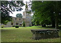
1
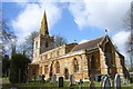
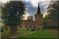
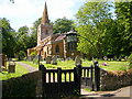
St Michael and All Angels', Bugbrooke
The local sandstone looks resplendent in sunshine.
Image: © Andrew Smith
Taken: 25 Mar 2006
0.11 miles
2
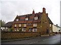
The Bakers Arms Pub, Bugbrooke
High Street, Bugbrooke, Northampton, NN7 3PG close to the Grand Union Canal
Image: © canalandriversidepubs co uk
Taken: Unknown
0.14 miles
3
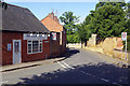
Great Lane, Bugbrooke
Great Lane leads away from the centre of this large village with the Village Takeaway on the left.
Image: © Stephen McKay
Taken: 17 Jul 2020
0.16 miles
4
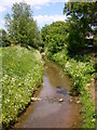
Bugbrooke Stream
The stream near the church heads north to join the River Nene.
Image: © Ian Rob
Taken: 30 May 2009
0.16 miles
5
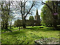
Bugbrooke Church
Saint Michael and All Angels.
Image: © Ian Rob
Taken: 30 May 2009
0.16 miles
6
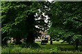
St Michael & All Angels Church, Bugbrooke
Image: © Mat Fascione
Taken: 1 Aug 2015
0.16 miles
7
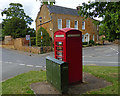
Telephone box along Bugbrooke High Street
Image: © Mat Fascione
Taken: 1 Aug 2015
0.16 miles