IMAGES TAKEN NEAR TO
Meadview, NORTHAMPTON, NN7 3BF
Introduction
This page details the photographs taken nearby to Meadview, NN7 3BF by members of the Geograph project.
The Geograph project started in 2005 with the aim of publishing, organising and preserving representative images for every square kilometre of Great Britain, Ireland and the Isle of Man.

There are currently over 7.5m images from over14,400 individuals and you can help contribute to the project by visiting https://www.geograph.org.uk
Image Map
Images are licensed for reuse under creativecommons.org/licenses/by-sa/2.0
Notes
- Clicking on the map will re-center to the selected point.
- The higher the marker number, the further away the image location is from the centre of the postcode.
Image Listing (8 Images Found)
Images are licensed for reuse under creativecommons.org/licenses/by-sa/2.0
Image
Details
Distance
2
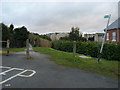
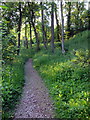
Bridleway down to Stoke Road
Off Courteenhall Road the bridleway down to Stoke Road
Image: © Shaun Ferguson
Taken: 26 Jan 2011
0.16 miles
4
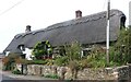
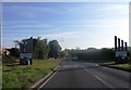
Thatched cottage on Stoke Road, Blisworth
Image: © David Howard
Taken: 1 Sep 2024
0.20 miles
5
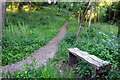
Bench by the path above the Grand Union
Image: © Philip Jeffrey
Taken: 1 Jun 2013
0.22 miles
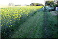
8
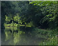
Tree lined cutting along the Grand Union Canal
Next to the northern portal of the Blisworth Tunnel.
Image: © Mat Fascione
Taken: 1 Aug 2015
0.24 miles