IMAGES TAKEN NEAR TO
Hartwell Road, NORTHAMPTON, NN7 2LH
Introduction
This page details the photographs taken nearby to Hartwell Road, NN7 2LH by members of the Geograph project.
The Geograph project started in 2005 with the aim of publishing, organising and preserving representative images for every square kilometre of Great Britain, Ireland and the Isle of Man.

There are currently over 7.5m images from over14,400 individuals and you can help contribute to the project by visiting https://www.geograph.org.uk
Image Map
Images are licensed for reuse under creativecommons.org/licenses/by-sa/2.0
Notes
- Clicking on the map will re-center to the selected point.
- The higher the marker number, the further away the image location is from the centre of the postcode.
Image Listing (3 Images Found)
Images are licensed for reuse under creativecommons.org/licenses/by-sa/2.0
Image
Details
Distance
1
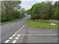
Passing Fox Covert Drive
Hartwell Road passing Fox Covert Drive
Image: © Shaun Ferguson
Taken: 12 May 2010
0.15 miles
3
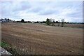
View from Ashton Road
Looking northeast from the old Stratford & Midland Junction Railway bridge at Roade along the path of the old railway line.
Image: © Bob Walters
Taken: 4 Apr 2022
0.22 miles