IMAGES TAKEN NEAR TO
Roade Hill, NORTHAMPTON, NN7 2JL
Introduction
This page details the photographs taken nearby to Roade Hill, NN7 2JL by members of the Geograph project.
The Geograph project started in 2005 with the aim of publishing, organising and preserving representative images for every square kilometre of Great Britain, Ireland and the Isle of Man.

There are currently over 7.5m images from over14,400 individuals and you can help contribute to the project by visiting https://www.geograph.org.uk
Image Map
Images are licensed for reuse under creativecommons.org/licenses/by-sa/2.0
Notes
- Clicking on the map will re-center to the selected point.
- The higher the marker number, the further away the image location is from the centre of the postcode.
Image Listing (25 Images Found)
Images are licensed for reuse under creativecommons.org/licenses/by-sa/2.0
Image
Details
Distance
1
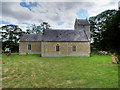
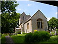
The Church of St Michael and All Angels, Ashton
The church of St Michael and All Angels dates from the fourteenth century. The West Tower was rebuilt in 1848 and the body of the church was restored in 1853 and again in 1911. It is a Grade II* listed building (Historic England List entry Number: 1190600 https://historicengland.org.uk/listing/the-list/list-entry/1190600 ).
Image: © David Dixon
Taken: 19 Aug 2018
0.06 miles
2
St Michael's Church, Ashton
The church of St Michael and All Angels at Ashton dates from the fourteenth century. The West Tower was rebuilt in 1848 and the body of the church was restored in 1853 and again in 1911. It is a Grade II* listed building (Historic England List entry Number: 1190600 https://historicengland.org.uk/listing/the-list/list-entry/1190600 ).
Image: © David Dixon
Taken: 19 Aug 2018
0.07 miles
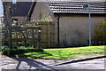
4
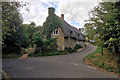
Thatched Cottage at Ashton
Thatched cottage on Roade Hill, just above St Michael's Church.
Image: © David Dixon
Taken: 19 Aug 2018
0.07 miles
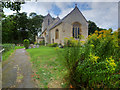
5
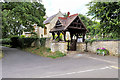
St Michael's Church and Lychgate, Ashton
The church of St Michael and All Angels dates from the fourteenth century. The West Tower was rebuilt in 1848 and the body of the church was restored in 1853 and again in 1911. It is a Grade II* listed building (Historic England List entry Number: 1190600 https://historicengland.org.uk/listing/the-list/list-entry/1190600 ).
Image: © David Dixon
Taken: 19 Aug 2018
0.07 miles
8
Ashton
The Church of Saint Michael and All Angels.
Image: © Ian Rob
Taken: 2 Jun 2007
0.10 miles