IMAGES TAKEN NEAR TO
Rowley Wood Lane, NORTHAMPTON, NN7 2HD
Introduction
This page details the photographs taken nearby to Rowley Wood Lane, NN7 2HD by members of the Geograph project.
The Geograph project started in 2005 with the aim of publishing, organising and preserving representative images for every square kilometre of Great Britain, Ireland and the Isle of Man.

There are currently over 7.5m images from over14,400 individuals and you can help contribute to the project by visiting https://www.geograph.org.uk
Image Map
Images are licensed for reuse under creativecommons.org/licenses/by-sa/2.0
Notes
- Clicking on the map will re-center to the selected point.
- The higher the marker number, the further away the image location is from the centre of the postcode.
Image Listing (6 Images Found)
Images are licensed for reuse under creativecommons.org/licenses/by-sa/2.0
Image
Details
Distance
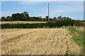
1
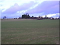
Ashwood Farm
View from Ashwood Lane, Hartwell.
Image: © John Eggins
Taken: 13 Dec 2003
0.04 miles
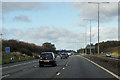
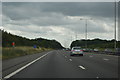
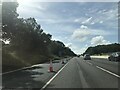
3
M1 motorway near Ashwood Farm
A relatively open view after Salcey Forest.
Image: © Peter Whatley
Taken: 3 Apr 2012
0.24 miles
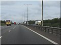
5
Electricity supply lines to Ashwood Farm
Image: © Philip Jeffrey
Taken: 8 Sep 2012
0.25 miles