IMAGES TAKEN NEAR TO
Whiston Road, NORTHAMPTON, NN7 1NL
Introduction
This page details the photographs taken nearby to Whiston Road, NN7 1NL by members of the Geograph project.
The Geograph project started in 2005 with the aim of publishing, organising and preserving representative images for every square kilometre of Great Britain, Ireland and the Isle of Man.

There are currently over 7.5m images from over14,400 individuals and you can help contribute to the project by visiting https://www.geograph.org.uk
Image Map
Images are licensed for reuse under creativecommons.org/licenses/by-sa/2.0
Notes
- Clicking on the map will re-center to the selected point.
- The higher the marker number, the further away the image location is from the centre of the postcode.
Image Listing (6 Images Found)
Images are licensed for reuse under creativecommons.org/licenses/by-sa/2.0
Image
Details
Distance
1
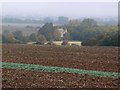
View towards Cottons Farmhouse
A misty morning view over the Nene Valley near Cogenhoe.
Image: © Michael Trolove
Taken: 7 Oct 2012
0.01 miles
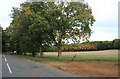
2
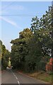
Field and woods by Whiston Road, Cogenhoe
Image: © David Howard
Taken: 9 Oct 2022
0.03 miles
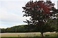
3
Field and woods by Whiston Road, Cogenhoe
Image: © David Howard
Taken: 9 Oct 2022
0.05 miles
4
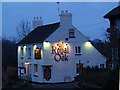
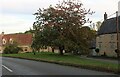
The Royal Oak Public House, Cogenhoe
This photo was taken in February 2006, shortly after the pub received its new sign.
Image: © Chris Walpole
Taken: 5 Feb 2006
0.14 miles