IMAGES TAKEN NEAR TO
The Leys, NORTHAMPTON, NN7 1DH
Introduction
This page details the photographs taken nearby to The Leys, NN7 1DH by members of the Geograph project.
The Geograph project started in 2005 with the aim of publishing, organising and preserving representative images for every square kilometre of Great Britain, Ireland and the Isle of Man.

There are currently over 7.5m images from over14,400 individuals and you can help contribute to the project by visiting https://www.geograph.org.uk
Image Map
Images are licensed for reuse under creativecommons.org/licenses/by-sa/2.0
Notes
- Clicking on the map will re-center to the selected point.
- The higher the marker number, the further away the image location is from the centre of the postcode.
Image Listing (26 Images Found)
Images are licensed for reuse under creativecommons.org/licenses/by-sa/2.0
Image
Details
Distance
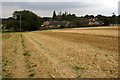
3
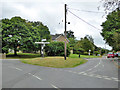
Triangular junction, Denton
Northampton Road right, Bedford Road left, with Whiston Road in the foreground.
Image: © Robin Webster
Taken: 4 Sep 2016
0.09 miles
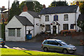
8
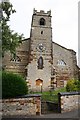
St.Margaret's church
A 13th century tower and late Georgian church
Image: © Richard Croft
Taken: 23 Aug 2007
0.12 miles
9
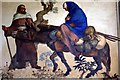
Flight into Egypt
Joseph coaxes a recalcitrant donkey; mural by Henry Bird (1976) in St Margaret's Church.
Image: © Tiger
Taken: 25 Aug 2007
0.12 miles
10
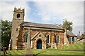
St.Margaret's church
A 13th century tower and a church of 1827-8 by Charles Squirhill
Image: © Richard Croft
Taken: 23 Aug 2007
0.12 miles