IMAGES TAKEN NEAR TO
Billing Road, NORTHAMPTON, NN7 1BL
Introduction
This page details the photographs taken nearby to Billing Road, NN7 1BL by members of the Geograph project.
The Geograph project started in 2005 with the aim of publishing, organising and preserving representative images for every square kilometre of Great Britain, Ireland and the Isle of Man.

There are currently over 7.5m images from over14,400 individuals and you can help contribute to the project by visiting https://www.geograph.org.uk
Image Map
Images are licensed for reuse under creativecommons.org/licenses/by-sa/2.0
Notes
- Clicking on the map will re-center to the selected point.
- The higher the marker number, the further away the image location is from the centre of the postcode.
Image Listing (23 Images Found)
Images are licensed for reuse under creativecommons.org/licenses/by-sa/2.0
Image
Details
Distance
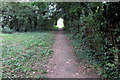
1
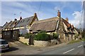
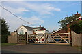
Lower End-Billing Road
Thatched cottage and surrounding houses.
Image: © Ian Rob
Taken: 9 Oct 2019
0.02 miles
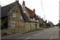
3
Cottage by the footpath to the church
Image: © Philip Jeffrey
Taken: 14 Sep 2014
0.03 miles
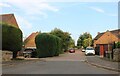
6
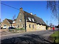
Billing Road
Stone houses and postbox in Lower End.
Image: © Burgess Von Thunen
Taken: 20 Apr 2013
0.07 miles
8
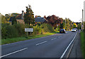
Northern Entrance to Brafield on the Green
Image: © Chris Walpole
Taken: 26 Sep 2006
0.12 miles
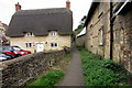
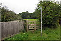
10
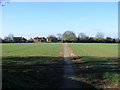
Footpath, looking towards Lower End
As accessed from the gate at the rear of the St Laurence churchyard.
Image: © Stuart Shepherd
Taken: 21 Feb 2009
0.13 miles