IMAGES TAKEN NEAR TO
Walgrave Road, NORTHAMPTON, NN6 9SX
Introduction
This page details the photographs taken nearby to Walgrave Road, NN6 9SX by members of the Geograph project.
The Geograph project started in 2005 with the aim of publishing, organising and preserving representative images for every square kilometre of Great Britain, Ireland and the Isle of Man.

There are currently over 7.5m images from over14,400 individuals and you can help contribute to the project by visiting https://www.geograph.org.uk
Image Map
Images are licensed for reuse under creativecommons.org/licenses/by-sa/2.0
Notes
- Clicking on the map will re-center to the selected point.
- The higher the marker number, the further away the image location is from the centre of the postcode.
Image Listing (26 Images Found)
Images are licensed for reuse under creativecommons.org/licenses/by-sa/2.0
Image
Details
Distance
1
Bus stop on Walgrave Road in Hannington
Image: © James Haynes
Taken: 1 Jan 2009
0.03 miles
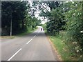
3
Walgrave Road, Hannington
Walgrave Road in the village of Hannington in Northamptonshire.
Image: © Malc McDonald
Taken: 28 Jul 2018
0.05 miles
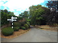
4
Hannington, Northamptonshire
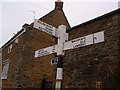
A road junction in village of Hannington in Northamptonshire.
Image: © Malc McDonald
Taken: 28 Jul 2018
0.06 miles
9
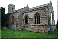
Hanington Church
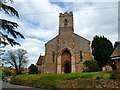
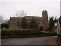
The Church of St. Peter and St. Paul is a lichen covered stone built church.
Image: © Malcolm Neal
Taken: 7 Nov 2004
0.08 miles
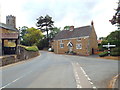
10
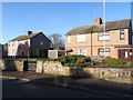
Main Street
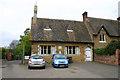
1930s council houses in Hannington.
Image: © Burgess Von Thunen
Taken: 31 Dec 2015
0.08 miles