IMAGES TAKEN NEAR TO
Vineyard Gardens, NORTHAMPTON, NN6 9FR
Introduction
This page details the photographs taken nearby to Vineyard Gardens, NN6 9FR by members of the Geograph project.
The Geograph project started in 2005 with the aim of publishing, organising and preserving representative images for every square kilometre of Great Britain, Ireland and the Isle of Man.

There are currently over 7.5m images from over14,400 individuals and you can help contribute to the project by visiting https://www.geograph.org.uk
Image Map
Images are licensed for reuse under creativecommons.org/licenses/by-sa/2.0
Notes
- Clicking on the map will re-center to the selected point.
- The higher the marker number, the further away the image location is from the centre of the postcode.
Image Listing (6 Images Found)
Images are licensed for reuse under creativecommons.org/licenses/by-sa/2.0
Image
Details
Distance
1
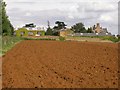
Hill Farm
Across a freshly ploughed field. The soil is showing up as very red in a sudden flash of sunlight.
Image: © Kokai
Taken: 22 Aug 2006
0.09 miles
2
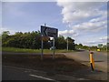
Roundabout on Harborough Road, Brixworth
Image: © David Howard
Taken: 21 May 2017
0.18 miles
3
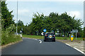
Roundabout on A508 Harborough Road
At the start of the Brixworth bypass.
Image: © Robin Webster
Taken: 23 Jun 2019
0.20 miles
4
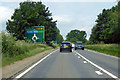
A508 Harborough Road
It is quite a long way round to the M1 via the A14.
Image: © Robin Webster
Taken: 23 Jun 2019
0.22 miles
5
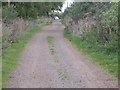
Cycleway on Pitsford Hill
Northampton Road can be seen at the end.
Image: © Kokai
Taken: 22 Aug 2006
0.22 miles
6
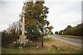
A508 and memorial
The A508 approaching Brixworth with the Chesham roadside memorial http://www.geograph.org.uk/photo/2666851
Image: © Richard Croft
Taken: 21 Oct 2011
0.23 miles