IMAGES TAKEN NEAR TO
Teeton Road, NORTHAMPTON, NN6 8LT
Introduction
This page details the photographs taken nearby to Teeton Road, NN6 8LT by members of the Geograph project.
The Geograph project started in 2005 with the aim of publishing, organising and preserving representative images for every square kilometre of Great Britain, Ireland and the Isle of Man.

There are currently over 7.5m images from over14,400 individuals and you can help contribute to the project by visiting https://www.geograph.org.uk
Image Map
Images are licensed for reuse under creativecommons.org/licenses/by-sa/2.0
Notes
- Clicking on the map will re-center to the selected point.
- The higher the marker number, the further away the image location is from the centre of the postcode.
Image Listing (3 Images Found)
Images are licensed for reuse under creativecommons.org/licenses/by-sa/2.0
Image
Details
Distance
1
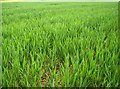
Wheat, barley or maize
Unlike many fields in the area which are full of readily identifiable rape, here is a field of a more traditional cereal crop. But which one? Clarification welcome.
Image: © Graham Horn
Taken: 25 Apr 2007
0.08 miles
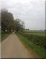
3
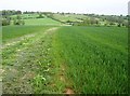
North east towards Creaton
The wide footpath heads across cropped fields and descends to a stream at the edge of the square beyond the hedge line. The A50 is on the hill on the horizon, with most of Creaton village hidden from view just over the brow.
Image: © Graham Horn
Taken: 25 Apr 2007
0.16 miles