IMAGES TAKEN NEAR TO
Teeton, NORTHAMPTON, NN6 8LS
Introduction
This page details the photographs taken nearby to NN6 8LS by members of the Geograph project.
The Geograph project started in 2005 with the aim of publishing, organising and preserving representative images for every square kilometre of Great Britain, Ireland and the Isle of Man.

There are currently over 7.5m images from over14,400 individuals and you can help contribute to the project by visiting https://www.geograph.org.uk
Image Map
Images are licensed for reuse under creativecommons.org/licenses/by-sa/2.0
Notes
- Clicking on the map will re-center to the selected point.
- The higher the marker number, the further away the image location is from the centre of the postcode.
Image Listing (15 Images Found)
Images are licensed for reuse under creativecommons.org/licenses/by-sa/2.0
Image
Details
Distance
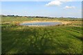
1
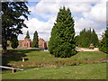
Ravensthorpe
Water Works at Ravensthorpe Reservoir. The Dam at the south eastern end can be seen beyond the buildings.
Image: © Ian Rob
Taken: 11 Aug 2006
0.07 miles
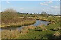
2
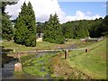
Ravensthorpe
The Outflow from Ravensthorpe Reservoir.
Image: © Ian Rob
Taken: 11 Aug 2006
0.07 miles
3
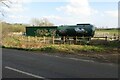
Storage tanks and graffiti by the waterworks
Image: © Philip Jeffrey
Taken: 26 Mar 2022
0.08 miles
5
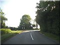
Bend on Teeton Road west of Ravensthorpe
Image: © David Howard
Taken: 21 May 2017
0.10 miles
6
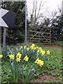
Spring flowers by the bridleway sign
Pointing the way from Ravensthorpe to Holdenby.
Image: © Jonathan Billinger
Taken: 3 Apr 2007
0.10 miles
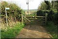
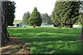
10
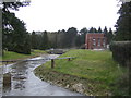
Water works and overflow channel
Of the Ravensthorpe reservoir.
Image: © Jonathan Billinger
Taken: 3 Apr 2007
0.16 miles