IMAGES TAKEN NEAR TO
Manor Road, NORTHAMPTON, NN6 8HN
Introduction
This page details the photographs taken nearby to Manor Road, NN6 8HN by members of the Geograph project.
The Geograph project started in 2005 with the aim of publishing, organising and preserving representative images for every square kilometre of Great Britain, Ireland and the Isle of Man.

There are currently over 7.5m images from over14,400 individuals and you can help contribute to the project by visiting https://www.geograph.org.uk
Image Map
Images are licensed for reuse under creativecommons.org/licenses/by-sa/2.0
Notes
- Clicking on the map will re-center to the selected point.
- The higher the marker number, the further away the image location is from the centre of the postcode.
Image Listing (76 Images Found)
Images are licensed for reuse under creativecommons.org/licenses/by-sa/2.0
Image
Details
Distance
1
School Road
School Road in Spratton is aptly named as it has a Church of England Primary School and a public School Spratton Hall along its length.
Image: © Malcolm Neal
Taken: 26 Aug 2020
0.03 miles
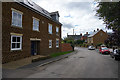
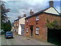
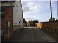
2
Manor Road
Stone cottages in Spratton.
Image: © Burgess Von Thunen
Taken: 14 Mar 2014
0.03 miles
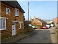
3
School Road Spratton
This quiet back street in the village of Spratton is just off the Brixworth Road. On a quiet Sunday it is idyllic. However at school start and end times this quiet road is very busy with parents in cars attempting to collect their children from the C of E Primary school and the small public school further along the road.
Image: © Malcolm Neal
Taken: 18 Jun 2017
0.03 miles
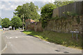
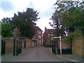
4
A gated housing estate
These houses are just off School Road in Spratton. It is a typical fairly modern group of houses with a gated entrance.
Image: © Malcolm Neal
Taken: 18 Jun 2017
0.03 miles
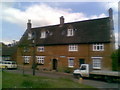
7
Manor Road
Stone cottages in Spratton.
Image: © Burgess Von Thunen
Taken: 14 Mar 2014
0.04 miles
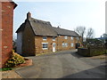
8
Erskine Wood
A private development of 1990s executive houses. Appears to be named after members of the Erskine Clan, who had a residence at Spratton Hall.
Image: © Burgess Von Thunen
Taken: 20 May 2010
0.04 miles
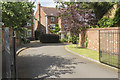
10
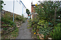
A narrow passageway
The narrow passageway connects two streets in Spratton. The high winds of the previous days have wreaked havoc with the Sunflower plants knocking all but one down.
Image: © Malcolm Neal
Taken: 26 Aug 2020
0.05 miles