IMAGES TAKEN NEAR TO
Cedar Hythe, NORTHAMPTON, NN6 8BG
Introduction
This page details the photographs taken nearby to Cedar Hythe, NN6 8BG by members of the Geograph project.
The Geograph project started in 2005 with the aim of publishing, organising and preserving representative images for every square kilometre of Great Britain, Ireland and the Isle of Man.

There are currently over 7.5m images from over14,400 individuals and you can help contribute to the project by visiting https://www.geograph.org.uk
Image Map
Images are licensed for reuse under creativecommons.org/licenses/by-sa/2.0
Notes
- Clicking on the map will re-center to the selected point.
- The higher the marker number, the further away the image location is from the centre of the postcode.
Image Listing (44 Images Found)
Images are licensed for reuse under creativecommons.org/licenses/by-sa/2.0
Image
Details
Distance
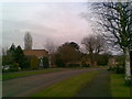
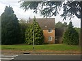
1

Cedar Hythe
1960s houses in Chapel Brampton.
Image: © Burgess Von Thunen
Taken: 4 Aug 2010
0.02 miles
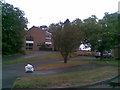
2

Cedar Hythe
1960s houses in Chapel Brampton.
Image: © Burgess Von Thunen
Taken: 4 Aug 2010
0.03 miles
3
Cedar Hythe
Interestingly-shaped 1960s houses.
Image: © Burgess Von Thunen
Taken: 9 Apr 2010
0.03 miles
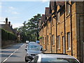
4
Welford Road, Chapel Brampton
Taken from the corner of the road to Church Brampton and Harlestone.
Image: © Kokai
Taken: 30 Aug 2006
0.06 miles
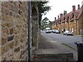
6
Northampton Road
Ironstone built houses along the main road through Chapel Brampton.
Image: © Oast House Archive
Taken: 2 Jul 2011
0.07 miles
7

Cedar Hythe
1960s houses in Chapel Brampton.
Image: © Burgess Von Thunen
Taken: 4 Aug 2010
0.07 miles
9
Cedar Hythe
1960s houses in Chapel Brampton.
Image: © Burgess Von Thunen
Taken: 4 Aug 2010
0.08 miles
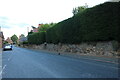
10

Beagle
Looking over the wall at N°17 onto the main road at Chapel Brampton.
Image: © Oast House Archive
Taken: 2 Jul 2011
0.08 miles