IMAGES TAKEN NEAR TO
Kilsby Road, NORTHAMPTON, NN6 7UT
Introduction
This page details the photographs taken nearby to Kilsby Road, NN6 7UT by members of the Geograph project.
The Geograph project started in 2005 with the aim of publishing, organising and preserving representative images for every square kilometre of Great Britain, Ireland and the Isle of Man.

There are currently over 7.5m images from over14,400 individuals and you can help contribute to the project by visiting https://www.geograph.org.uk
Image Map
Images are licensed for reuse under creativecommons.org/licenses/by-sa/2.0
Notes
- Clicking on the map will re-center to the selected point.
- The higher the marker number, the further away the image location is from the centre of the postcode.
Image Listing (19 Images Found)
Images are licensed for reuse under creativecommons.org/licenses/by-sa/2.0
Image
Details
Distance
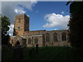
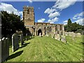
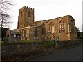
1
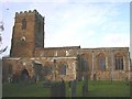
Watford
Church of St Peter and Paul, in need of some repair.
Image: © Ian Rob
Taken: 2 Dec 2005
0.01 miles
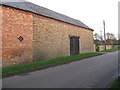
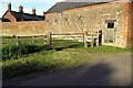
4
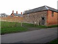
Watford-Kilsby Road
Old Barn on Kilsby Road.
Image: © Ian Rob
Taken: 30 Nov 2011
0.03 miles
10
Watford-Church Street
Stone House in Church Street.
Image: © Ian Rob
Taken: 30 Nov 2011
0.10 miles