IMAGES TAKEN NEAR TO
Buswell Paddock, NORTHAMPTON, NN6 7SA
Introduction
This page details the photographs taken nearby to Buswell Paddock, NN6 7SA by members of the Geograph project.
The Geograph project started in 2005 with the aim of publishing, organising and preserving representative images for every square kilometre of Great Britain, Ireland and the Isle of Man.

There are currently over 7.5m images from over14,400 individuals and you can help contribute to the project by visiting https://www.geograph.org.uk
Image Map
Images are licensed for reuse under creativecommons.org/licenses/by-sa/2.0
Notes
- Clicking on the map will re-center to the selected point.
- The higher the marker number, the further away the image location is from the centre of the postcode.
Image Listing (10 Images Found)
Images are licensed for reuse under creativecommons.org/licenses/by-sa/2.0
Image
Details
Distance
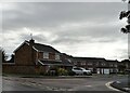
1
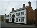
Long Buckby-The Admiral Rodney
A Public house on High Street.
Image: © Ian Rob
Taken: 15 Mar 2008
0.05 miles
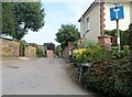
2
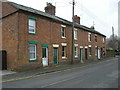
Long Buckby-High Street
Cottages near The Admiral Rodney.
Image: © Ian Rob
Taken: 15 Mar 2008
0.06 miles
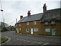
3
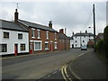
Long Buckby-High Street
Cottages on High Street.
Image: © Ian Rob
Taken: 15 Mar 2008
0.11 miles
4
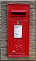
Elizabeth II postbox on East Street
Postbox No. NN6 526.
Image: © JThomas
Taken: 27 Sep 2022
0.12 miles
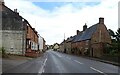
6
Long Buckby-High Street
Cottages on the bend.
Image: © Ian Rob
Taken: 15 Mar 2008
0.13 miles
9
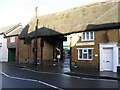
Spot the Co-op
Flanked by Peep Hole crafts shop and a Dental practice the thatched passage way leads to a modest sized Co-operative food store.
Image: © Michael Trolove
Taken: 6 Dec 2009
0.24 miles
10
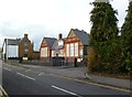
Long Buckby Infant School
On High Street. http://www.longbuckbyinfantschool.org.uk/
Image: © Mike Faherty
Taken: 30 Oct 2011
0.25 miles