IMAGES TAKEN NEAR TO
Millers Road, NORTHAMPTON, NN6 6NE
Introduction
This page details the photographs taken nearby to Millers Road, NN6 6NE by members of the Geograph project.
The Geograph project started in 2005 with the aim of publishing, organising and preserving representative images for every square kilometre of Great Britain, Ireland and the Isle of Man.

There are currently over 7.5m images from over14,400 individuals and you can help contribute to the project by visiting https://www.geograph.org.uk
Image Map
Images are licensed for reuse under creativecommons.org/licenses/by-sa/2.0
Notes
- Clicking on the map will re-center to the selected point.
- The higher the marker number, the further away the image location is from the centre of the postcode.
Image Listing (44 Images Found)
Images are licensed for reuse under creativecommons.org/licenses/by-sa/2.0
Image
Details
Distance
1
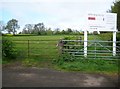
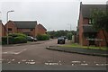
Welford: Footpath from Court Lane
This is the footpath as it approaches the current built-up area of Welford with the houses on Newlands Road in view. Given that the white notice board tells us that Mears Homes plan to develop the site it could be that this will be the last ever photograph of this view with the grass field present. The mound of disturbed ground by the footpath is the residue of some soil testing in advance of the building work commencing. This view was taken from the top of a stile in a hedgerow.
Image: © Nigel Cox
Taken: 7 May 2015
0.03 miles
2
Welford: Footpath to Court Lane
This footpath meanders through the fields down to Court Lane, and was taken from the top of a stile in a hedgerow.
Image: © Nigel Cox
Taken: 7 May 2015
0.05 miles
3
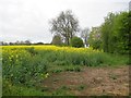
Welford: Mears Homes development site
Mears Homes plan to develop this field, on the south side of Newlands Road, and on the south side of the village, into a housing estate containing a range of 2 to 5 bedroom properties.
Image: © Nigel Cox
Taken: 7 May 2015
0.05 miles
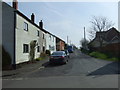
4
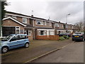
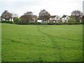
The Leys
1980s houses in Welford.
Image: © Burgess Von Thunen
Taken: 5 Feb 2016
0.09 miles
6
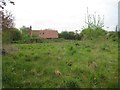
Welford: Paddock off Newlands Road
Recent satellite imagery shows several buildings in this paddock but now only the derelict structure in the distance is left.
Image: © Nigel Cox
Taken: 7 May 2015
0.11 miles
9
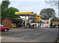
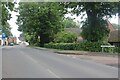
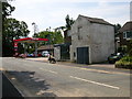
Welford: St1 Welford Garage
When Ian photographed this garage in 2009 Image it was owned by Murco (the US Murphy Oil Company). Murco have since disposed of their garage forecourt business in the UK, and this one appears to have been purchased by the Finnish energy company St1 Oy, which operates service stations in Finland, Sweden, Norway and Poland. For the record unleaded was 116.9 pence and diesel 121.9 pence a litre on the day.
The road is the A5199 Northampton Road, once the A50.
Image: © Nigel Cox
Taken: 7 May 2015
0.14 miles