IMAGES TAKEN NEAR TO
Holdenby Lane, NORTHAMPTON, NN6 0RN
Introduction
This page details the photographs taken nearby to Holdenby Lane, NN6 0RN by members of the Geograph project.
The Geograph project started in 2005 with the aim of publishing, organising and preserving representative images for every square kilometre of Great Britain, Ireland and the Isle of Man.

There are currently over 7.5m images from over14,400 individuals and you can help contribute to the project by visiting https://www.geograph.org.uk
Image Map
Images are licensed for reuse under creativecommons.org/licenses/by-sa/2.0
Notes
- Clicking on the map will re-center to the selected point.
- The higher the marker number, the further away the image location is from the centre of the postcode.
Image Listing (4 Images Found)
Images are licensed for reuse under creativecommons.org/licenses/by-sa/2.0
Image
Details
Distance
1
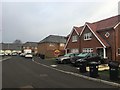
Thorpe Road
Redrow homes constructed circa 2016.
Image: © Burgess Von Thunen
Taken: 18 Jan 2019
0.15 miles
4
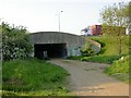
Underpass for the A45
For pedestrians and non-motorised vehicles only. Leads through to what is now the northern section of Station Road which runs to the centre of Earls Barton.
Image: © Kokai
Taken: 11 May 2006
0.24 miles